Publications
Le M23 « version 2 » : Enjeux, motivations, perceptions et impacts locaux
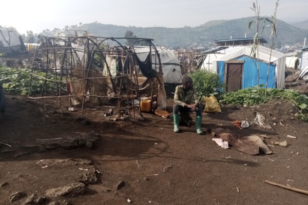
Depuis 2021, l’est de la République démocratique du Congo (RDC) est à nouveau sous l’emprise du groupe armé du « Mouvement du 23 mars » (M23). Défait en 2013, le M23 a repris les armes en 2021, et réussissait en 2022 à s’emparer rapidement de vastes territoires au sud-est de la province du Nord-Kivu.
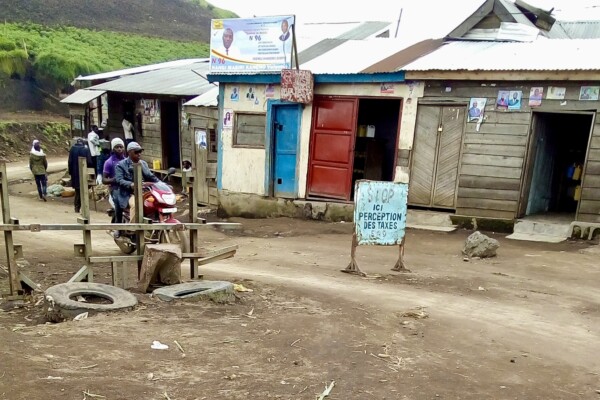
Barrages routiers à Masisi et Walikale: Prédation sur la circulation en période de troubles
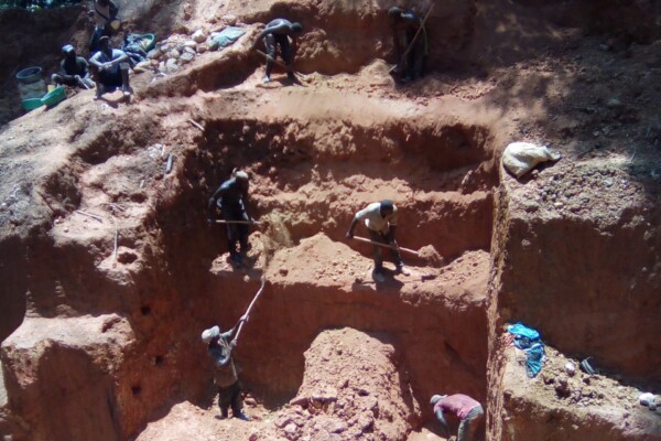
Si les minerais sont au centre des recherches sur le financement des conflits en République démocratique du Congo, les acteurs armés ont souvent recours à d’autres sources de revenus pour financer leurs luttes. Lesbarrages routiers en font. Dans ce rapport, produit en collaboration avec ASSODIP et le Danish Institute for International Studies (DIIS), IPIS étudie le lien entre les barrages routiers
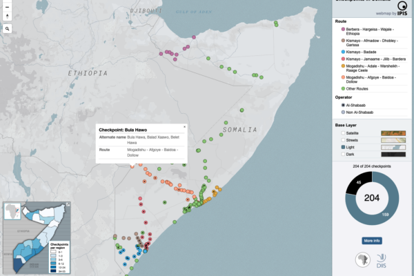
Mapping the political economy of checkpoints in Somalia
- IPIS | 20 décembre 2023
The maps inform users on the locations of roadblocks across Somalia, the distribution of violence at checkpoints as well as the density of checkpoints per administrative region. Different maps also identify varying characteristics of the roadblocks, including their operator, location on a primary/secondary road and the amount paid at the checkpoint as toll.
Checkpoint economy: the political economy of checkpoints in South Sudan, ten years after independence
- Ken Matthysen, Peer Schouten | 10 décembre 2021
Ten years after independence, the world’s youngest country is home to an entrenched political economy of conflict premised on checkpoint taxation. Humanitarian aid is not exempt, reveals a major new mapping report by DIIS and IPIS. When South Sudan became independent ten years ago, oil revenues were supposed to fuel the economy of the world’s newest country. But two years later in 2013, oil prices
Plaidoyer en faveur d’un environnement plus favorable à la production, au commerce et à l’exportation de minerais conformes au Guide OCDE sur le devoir de diligence (GDD) dans l’est de la RDC.
- Levin Sources | 23 novembre 2021
Dans le cadre du projet Madini, un examen de la situation actuelle, des tendances et des obstacles à la production, au commerce et à l’exportation d’étain, de tantale, de tungstène (3T) et d’or en provenance de l’est de la République démocratique du Congo (RDC) a été réalisé par Levin Sources, dans le but de recommander des actions concrètes susceptibles d’améliorer l’approvisionnement conforme à
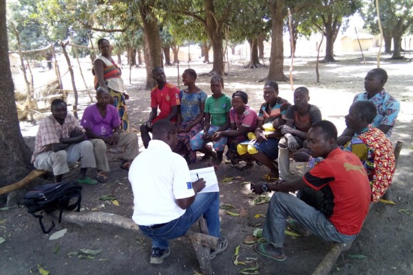
Promoting peaceful and seasonal migration in Northern Central African Republic
- Guillaume de Brier, Peer Schouten (DIIS/IPIS) | 9 février 2021
“You can negotiate with an armed group, not with the drought” The borderlands of the Central African Republic (CAR) are home to one of the largest seasonal livestock migrations (transhumance) in the world. Decades of unrest and crisis, however, have brutally disrupted most aspects of herding—the routes taken, the people involved, governance mechanisms, as well as relations to local populations. To
Annual Report 2019
- IPIS | 26 août 2020
This 2019 annual report provides an overview of IPIS’ research projects, capacity enhancement and outreach activities throughout last year. Read the full activity report to see what IPIS has been up to in 2019.
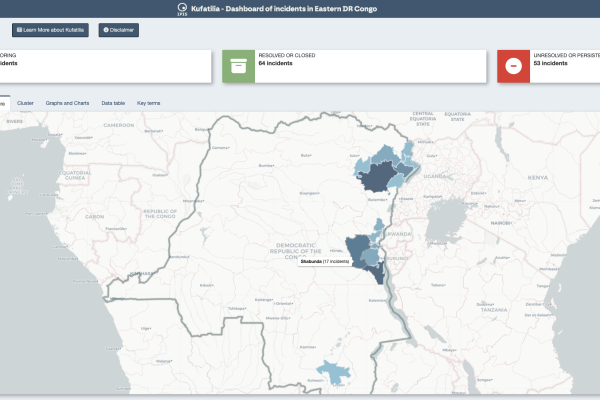
Dashboard of incidents in eastern DRC – Kufatilia
- Thomas Muller | 10 juin 2020
The Kufatilia platform (“to track” in Swahili) is an SMS based incident reporting and follow-up mechanism that has been launched in 2019 to increase transparency of minerals supply chains in Eastern DRC. Developed by IPIS in partnership with the Centre for Expertise on Mining Governance (CEGEMI) based in Bukavu, and powered by Ulula, Kufatilia is a tool for Congolese civil society organisations to
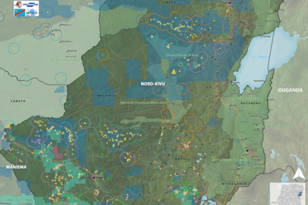
Maps of conflict minerals in Eastern DRC (2020)
- Alexandre Jaillon | 9 juin 2020
IPIS created maps of conflict minerals in eastern DRC, more particularly on Haut Uele, Ituri and North and South Kivu. These maps detail the type of minerals, the qualification of the mines, the mining titles and give an overview of armed presence in and around the mines. d Download the North Kivu map in full resolution Download the South Kivu map in full resolution Download the Haut
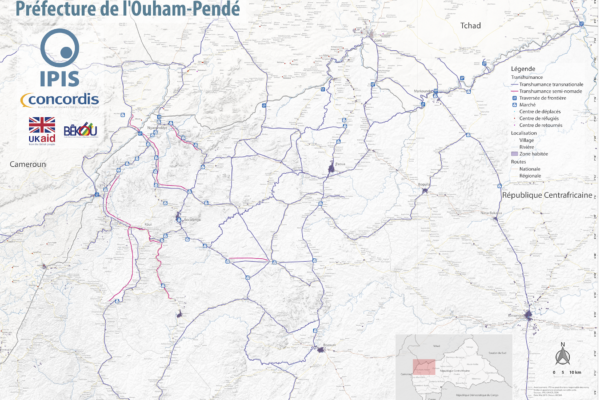
Map Pastoralism Ouham Pendé (2019)
- Alexandre Jaillon | 12 septembre 2019
Each year the annual migration of transnational transhumance through the prefecture of Ouham-Pende, in northwestern Central African Republic (CAR), uproots a deep-seated mistrust between nomadic and sedentary communities. Escalating militancy and environmental pressures in the region has only amplified these issues in recent years.In partnership with Concordis International, IPIS hopes to enhance
Annual Report 2018
- IPIS | 27 juin 2019
This 2018 annual report provides an overview of IPIS’ research projects, capacity enhancement and outreach activities throughout last year. IPIS consolidated its work in DRC, Central African Republic and Tanzania and deepened its expertise on mapping, data analysis and research on conflict drivers, natural resources, Business & Human Rights and arms trade. IPIS worked closely with civil societ

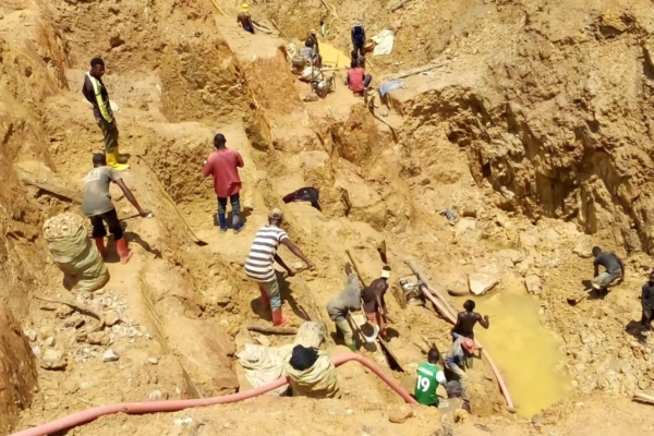
Cartographie des zones minières artisanales et des chaînes d’approvisionnement en minéraux dans l’est de la RDC
- Ken Matthysen, Peer Schouten (DIIS/IPIS), Steven Spittaels | 22 avril 2019
Dans son dernier rapport et sa dernière webmap, IPIS présente ses données actualisées sur l’impact des conflits armés et de l’ingérence des groupes armés dans le secteur minier artisanal dans l’est de la République Démocratique du Congo. En s’appuyant sur une vaste base de données collectées sur les dix dernières années, IPIS évalue l’impact des initiatives d’approvisionnement responsables qui vis
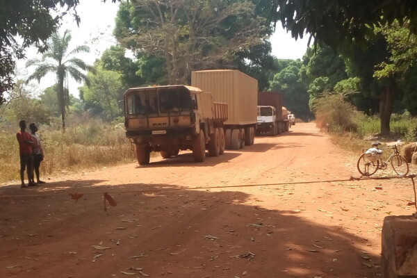
Article – The Political Economy of Roadblocks in the Central African Republic
- Alexandre Jaillon, Peer Schouten (DIIS/IPIS), Soleil Kalessopo | 2 octobre 2018
From September 2016 to September 2017, the International Peace Information Service (IPIS) and the Danish Institute for International Studies (DIIS) conducted a mapping of roadblocks in the Central African Republic. This data collection campaign also features more than 200 interviews with various actors and was combined with data from other reports on roadblocks to form a comprehensive study on the

Central African Republic – Ouham-Pende Basemap (2019)
- Alexandre Jaillon, Emily Doerner | 17 septembre 2018
Each year the annual migration of transnational transhumance through the prefecture of Ouham-Pende, in northwestern Central African Republic (CAR), uproots a deep-seated mistrust between nomadic and sedentary communities. Escalating militancy and environmental pressures in the region has only amplified these issues in recent years. These maps, created by IPIS, detail the towns, villages, roads, ID
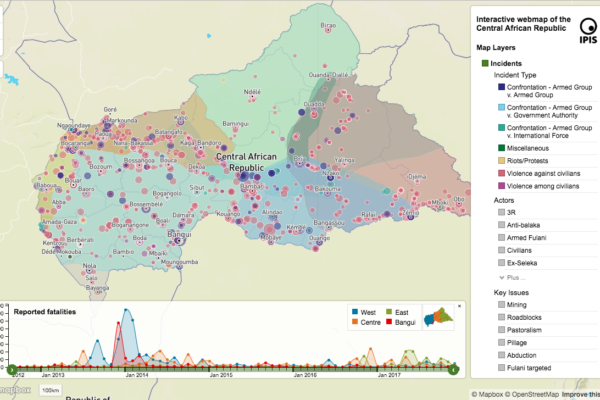
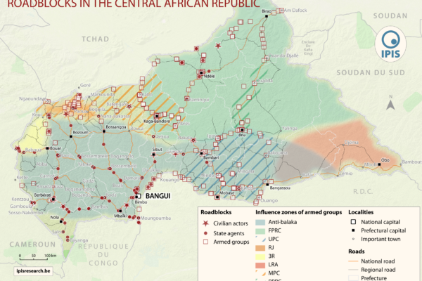
République centrafricaine: cartographie du conflit
- IPIS | 16 septembre 2018
Dans un nouveau rapport et une nouvelle carte web sur la crise en République centrafricaine (RCA), IPIS souligne que l’accès aux ressources reste le principal moteur de l’armement et des conflits en RCA. Tous les groupes armés opérant en RCA se livrent à la prédation sur un ou plusieurs secteurs économiques. Une telle prédation est non seulement un facteur déterminant des mouvements et des activit
Annual Report 2017
- IPIS | 21 août 2018
In its 2017 annual report, IPIS gives an overview of its research projects and activities. It covers the four research programmes that IPIS focusses on: natural resources, arms trade, conflict mapping and business and human rights. IPIS explains among others its mapping work of artisanal mining sites in the Democratic Republic of Congo, its work on Human Rights in mining in Northwest Tanzania an
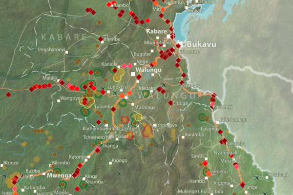
Barrières routières et sites miniers artisanaux – Provinces du Nord- et du Sud-Kivu (2018)
- Maryam Zarkeyvan | 20 mars 2018
Cette carte montre l’emplacement des barrières routières et des sites miniers artisanaux dans les provinces du Kivu. Elle a été créé en combinant les jeux données de notre rapport récent sur les barrières routières dans la région, et de la récente mise à jour de notre base de données et notre carte interactive sur les sites miniers artisanaux dans l’est de la RDC. Téléchargez la carte

Interactive map of artisanal mining exploitation in eastern DR Congo – 2018 update
- Ken Matthysen | 19 mars 2018
Résumé français ci-dessous – French summary below IPIS launched a major update of it’s DRC webmap displaying data on more than 2400 artisanal mining sites in eastern DRC and more than 800 roadblocks. Since December 2016, IPIS teams have visited more than 500 artisanal mines in eastern DRC, gathering data that has been added to IPIS’ interactive webmap. IPIS also integrated other datasets gathered
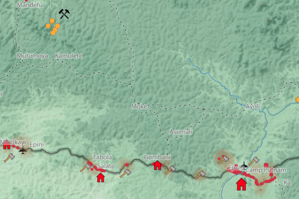
Okapi Wildlife Reserve: Illegal Sourcing of Gold and Timber (2018)
- Manuel Claeys Bouuaert, Maryam Zarkeyvan | 1 février 2018
A map of the Okapi Wildlife Reserve in DRC, created as a result of two mapathons focussing on illegal activities in the park.
« Laissez-piller » L’économie politique des barrières routières en République centrafricaine
- Alexandre Jaillon, Peer Schouten (DIIS/IPIS), Soleil Kalessopo | 7 décembre 2017
IPIS, l’institut belge de recherche, dresse la carte des barrages routiers et pointe leur rôle clé dans les mécanismes de financement des conflits en Afrique centrale et des acteurs armés en République démocratique du Congo(RDC) et en République centrafricaine. Deux rapports de IPIS révèlent l’étendue de l’emprise des acteurs armés sur les routes commerciales en Afrique centrale, une région en pr