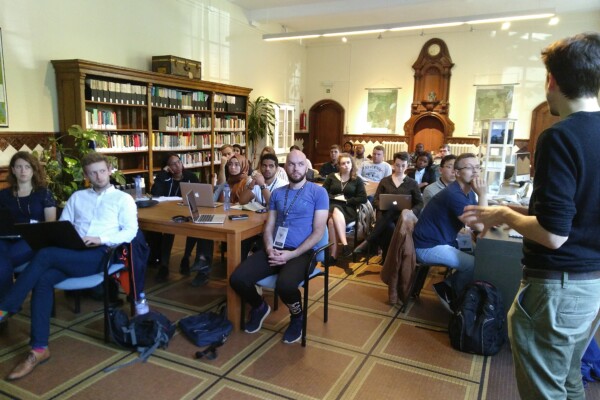
IPIS welcomes UA Summer School students for workshop on responsible sourcing using IPIS maps
September 10, 2018On September 6th, 30 students from the University of Antwerp ‘Mine to Finger’ Summer School on diamonds participated in a responsible sourcing workshop organised by IPIS. They explored the upstream context of the diamond supply chain in Central African Republic (CAR) and the Democratic Republic Congo (DRC) using IPIS webmaps. They engaged in a critical and nuanced discussion on various due dilig
Open data – Getting started using Excel
August 27, 2018Since 2009, the International Peace Information Service manages a database on mining site visits in eastern DR Congo. Since January 2017, IPIS publishes the data it has collected over the last decade on its Open Data page. This tutorial explains how to get started with the IPIS Open Data if you are using Microsoft Excel. Other documentation to this data includes an Open Data FAQ & Dictionary p
Annual Report 2017
August 21, 2018In its 2017 annual report, IPIS gives an overview of its research projects and activities. It covers the four research programmes that IPIS focusses on: natural resources, arms trade, conflict mapping and business and human rights. IPIS explains among others its mapping work of artisanal mining sites in the Democratic Republic of Congo, its work on Human Rights in mining in Northwest Tanzania an
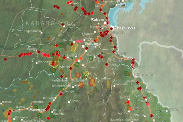
Roadblocks and artisanal mining sites – North and South Kivu Provinces (2018)
March 20, 2018This map show the location of roadblocks and artisanal mining sites in the Kivu provinces. It was made by combining data from our recent report on roadblocks in the area, and data from our recent update of our database and webmap on artisanal mining sites in eastern DRC. Download the full image

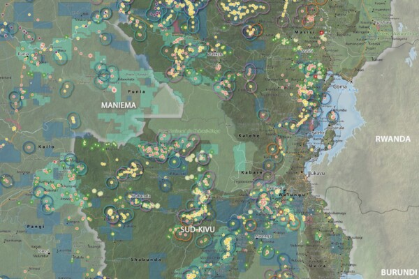
Interactive map of artisanal mining exploitation in eastern DR Congo – 2018 update
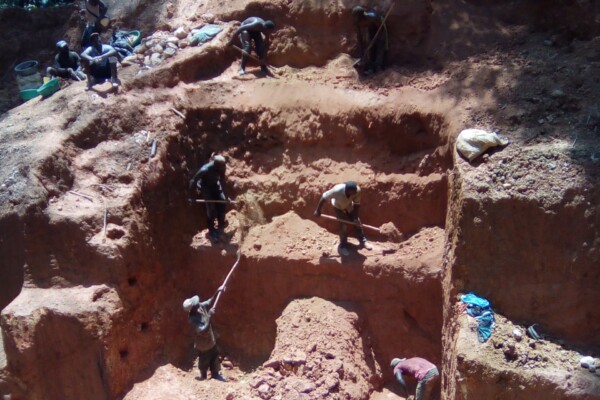
March 19, 2018Résumé français ci-dessous – French summary below IPIS launched a major update of it’s DRC webmap displaying data on more than 2400 artisanal mining sites in eastern DRC and more than 800 roadblocks. Since December 2016, IPIS teams have visited more than 500 artisanal mines in eastern DRC, gathering data that has been added to IPIS’ interactive webmap. IPIS also integrated other datasets gathered
Training and workshop on mapping artisanal mining in Eastern DRC
February 9, 2018(French version below) 2373 Mining sites visited, including 470 visits in the last thirteen months. 300 Roadblocks visited on a total of 798 mapped roadblocks. More than 18 000 km travelled by plane, bus, motorbikes and by foot… These are a few of the impressive results achieved by the twelve IPIS researchers in Eastern DRC. Late January, a workshop held in Goma gave IPIS researchers an opportun
Mitigating conflict and reducing environmental impacts of ASM in protected areas
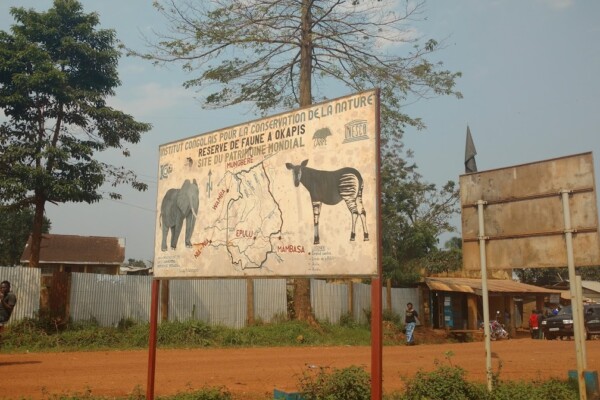
February 3, 2018The Wildlife Conservation Society (WCS) and IPIS have been partnering in 2018-2019 to investigate the situation of Artisanal and Small-scale Mining (ASM) within and around Kahuzi-Biega National Park (KBNP) and the Okapi Wildlife Reserve (OWR) in eastern DRC. Both protected areas are listed as UNESCO World Heritage Sites.The activities include research, development of surveys, training surveyors, c
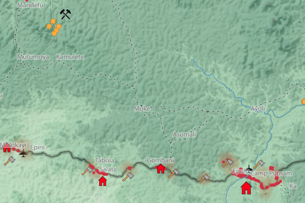
Okapi Wildlife Reserve: Illegal Sourcing of Gold and Timber (2018)
February 1, 2018A map of the Okapi Wildlife Reserve in DRC, created as a result of two mapathons focussing on illegal activities in the park.
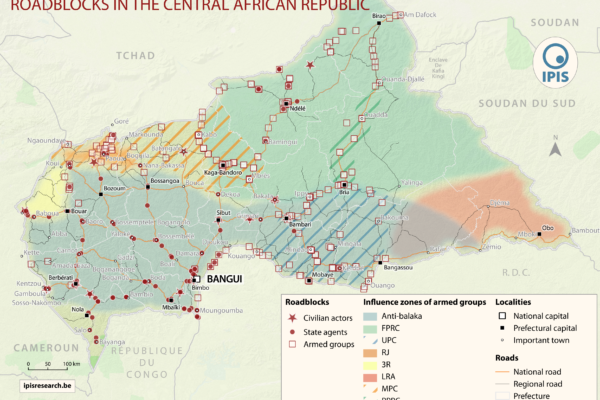
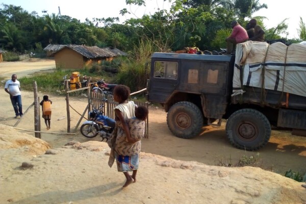
The Politics of Pillage: the political economy of roadblocks in the Central African Republic (2017)
December 7, 2017IPIS puts roadblocks on the map as key mechanism of conflict funding besides natural resources, revealing its devastating scope in funding armed actors in Democratic Republic of Congo and Central African Republic Mapping over a thousand roadblocks, IPIS uncovers the shocking extent of armed predation on trade routes in conflict-ridden Central Africa. Roadblocks, IPIS claims, have netted armed grou
Roadblock rebels: IPIS maps important mechanism of conflict funding in Central Africa
December 6, 2017IPIS puts roadblocks on the map as key mechanism of conflict funding besides natural resources, revealing its devastating scope in funding armed actors in Democratic Republic of Congo and Central African Republic Mapping over a thousand roadblocks, two IPIS reports released today have uncovered the shocking extent of armed predation on trade routes in conflict-ridden Central Africa. Roadbloc
“Everything that moves will be taxed”: the political economy of roadblocks in North and South Kivu (2017)
December 6, 2017IPIS puts roadblocks on the map as key mechanism of conflict funding besides natural resources, revealing its devastating scope in funding armed actors in Democratic Republic of Congo and Central African Republic Mapping over a thousand roadblocks, IPIS shows the shocking extent of armed predation on trade routes in conflict-ridden Central Africa. Roadblocks, IPIS claims, have netted armed groups
Mapping roadblocks in eastern DRC
December 3, 2017Dates: 2017 – 2018 Location(s): Eastern DRC Research Programme(s): Conflict Mapping Funder(s): IOM Partner(s): DIIS, ASSODIP Activities: Deliverable(s): Project Coordinator Ken Matthysen Researcher e-mail This is the preview of the “Coordinator Project” View. Related Publication(s) Roadblocks and artisanal mining sites – North and South Kivu Provinces (2018) “Everything that moves will
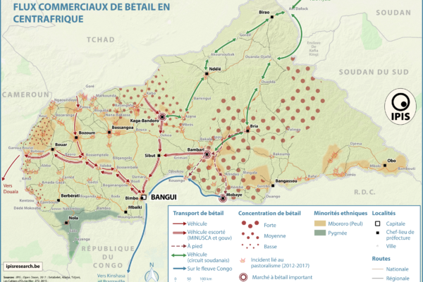
Pastoralism corridors in Central African Republic (2017)
December 1, 2017While pastoralism can generates wealth and economic interdependence between farmers and cattle herders, it can also causes tension and conflicts. In the current Central African Republic crisis context, transnational livestock migrations, particularly by Chadian and Sudanese herdsmen to CAR, have led to clashes between pastoralists and the local population. IPIS has developed a map showing the main

New Mapathon with special focus on DRC National Parks at IPIS
November 23, 2017IPIS, Missing Maps and OpenStreetMap Belgium organise another Missing Maps Mapathon on Wednesday December 6, in the IPIS library. Why do we organise this? NGOs working in the South need decent maps in order to reach people who need help. However, in many places the map is not yet complete. That’s why we need your help! How do we help? We teach volunteers how to trace satellite imagery in

Towards a multi-scale approach for an Earth observation based assessment of natural resource exploitation in conflict regions
November 6, 2017Environment and natural resources can be key elements in starting and fueling conflicts. IPIS researcher Filip Hilgert contributed to an article in Geocarto International (2017, vol. 32, n° 10) on a multi-scale approach for an Earth observation based assessment of natural resource exploitation in conflict regions. Download the full article Elisabeth Schoepfer, Kristin Spröhnle, Olaf Kranz, Xavier
Conflict Minerals in Eastern DRC (2017)
September 22, 2017Printing maps of conflict minerals in Eastern DRC.
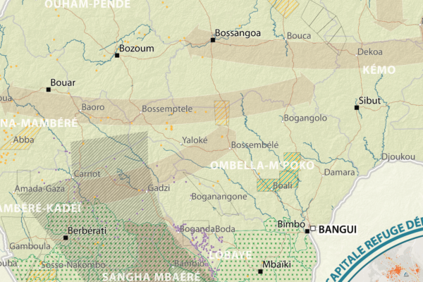
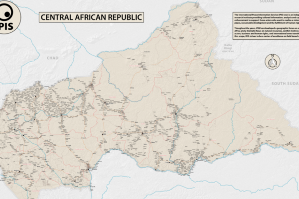
République Centrafricaine: Portait d’un territoire riche en crises (2012 – 2017)
September 19, 2017This poster is a compilation of maps and graphics related to the situation in the Central African Republic. A map of natural resources and poaching corridors presents the known wealth of this country, often considered as conflict drivers in the absence of well functioning state authorities. A small map presents the current armed groups area of influence as well as the number of reported violent in
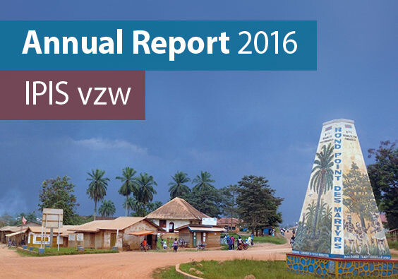
Annual report 2016
June 23, 2017In its 2016 annual report, IPIS gives an overview of its research projects and activities. It covers the four research programmes that IPIS focusses on: natural resources, arms trade, conflict mapping and business and human rights. In 2016, IPIS continued to be a rally point for hard to get data on natural resources, often visualised in maps. Our flagship map for 2016 is the interactive map of art
Open data FAQ & dictionary
June 21, 2017This page lists some Frequently Asked Questions (FAQ) about the IPIS Open Data, and helps you understand the meaning of the different columns and values that occur in the data. If you still have questions, don’t hesitate to contact us! 1. Frequently Asked Questions 1.1. FAQ’s about IPIS Open Data in general Which data does IPIS publish?IPIS publishes a selection of its datasets, which originate fr
Central African Republic – Road Map (2017)
June 1, 2017In 2013 the Central African Republic entered a period of great instability. The predominantly Muslim rebel coalition, Seleka, seized power. A group of mostly Christian militias, the Anti-balaka, rose up to counter the Seleka. Years of atrocities, horrors and fighting followed. In 2016 a democratic election was held, a sign of hope for the people of the CAR. However, dissolved fractions of the Sele