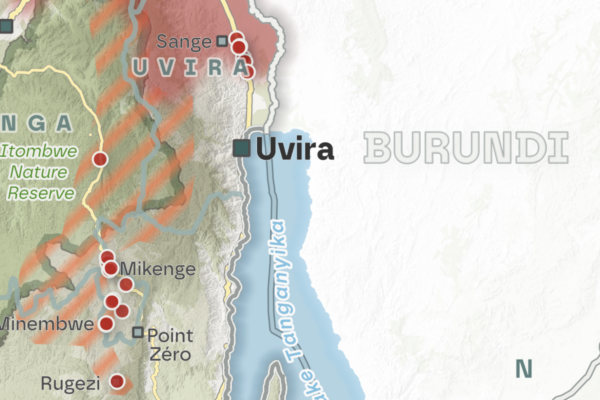
Shifting frontlines in 2026: New year – old challenges. Hostilities in eastern DRC continue amid increased diplomatic efforts
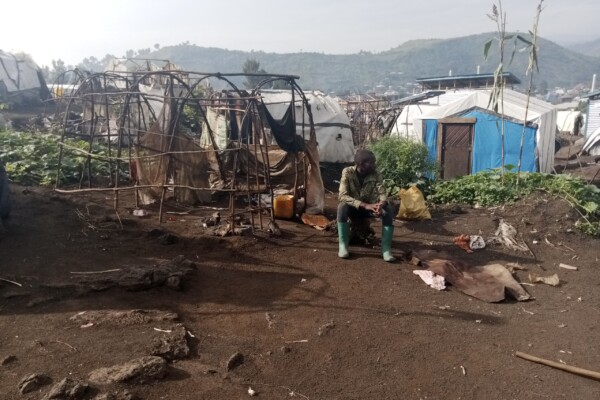
June 25, 2026As the conflict in eastern DRC entered its third year of major hostilities between the Rwanda-backed AFC/M23 alliance and the FARDC/Wazalendo coalition, diplomatic efforts continued in early 2026 to advance the peace process. Despite renewed diplomatic momentum and both parties’ stated commitment to the peace processes, the situation on the ground remained marked by continuous violent clashes, shi
Annual Report 2025
June 24, 2026Looking back at 2025, we witnessed a year that was defined by escalating conflicts. The AFC/M23’s capture of the provincial capitals of Goma and Bukavu in eastern Democratic Republic of Congo (DRC) in early 2025 directly impacted our team, partners, and activities focused on peace and natural resource governance. The rebel group’s territorial advance and the resulting violence – both with the Cong

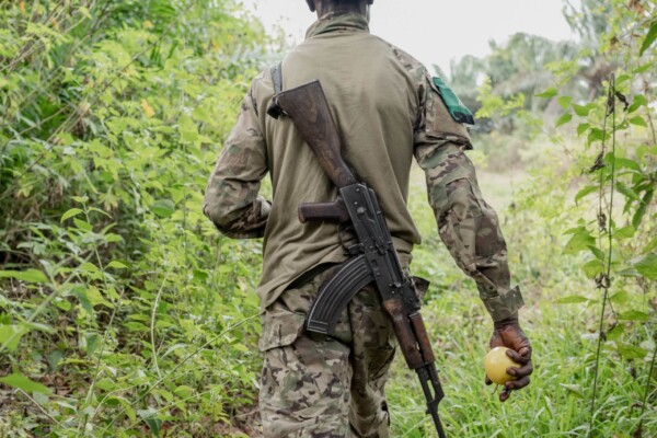
The emergence of the Wazalendo in the fight against the AFC/M23 in North Kivu: Current situation, challenges and prospects
February 5, 2026On January 27, 2025, the Congo River Alliance/March 23 Movement (AFC/M23) – supported by Rwanda – took control of Goma, the capital of North Kivu province in the Democratic Republic of Congo (DRC), and then moved on to Bukavu, the capital of South Kivu, which fell in February 2025. The re-emergence of M23 in 2021 and its rapid advance prompted the Congolese government to resort to non-state armed

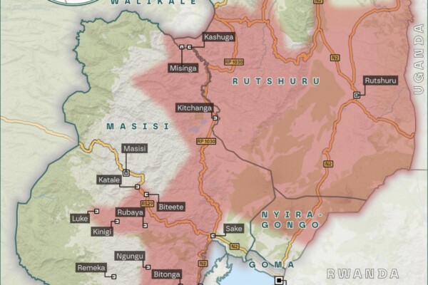
Shifting frontlines in October, November and December – Limits of diplomacy: AFC/M23 advances after Washington Accords
December 19, 2025On 4 December 2025, Rwanda and the Democratic Republic of the Congo (DRC) signed the US-brokered Washington Accords for Peace and Prosperity, committing to cease hostilities, establish a permanent ceasefire, and implement the 25 April Declaration of Principles and the 27 June Peace Agreement. However, critical questions have been raised about the prospects for lasting peace in eastern DRC, as Kig

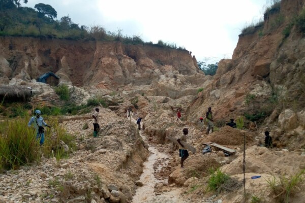
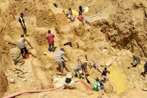
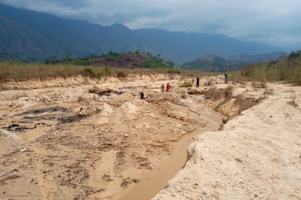
Workshops to present the results of the mapping of artisanal mining sites carried out in Ituri
December 19, 2025Following this research, the results were presented in workshops in the above-mentioned territories to mining monitoring committees and project stakeholders in August 2025, facilitated by the IPIS focal point, Justice Plus staff and the IPIS research team. The aim of these feedback sessions was to share the results of our research with local actors in order to make them more accessible, enable the
The weight of silence: How the Mobondo revolt is shaking western DRC
November 20, 2025Since 2022, western Democratic Republic of Congo (DRC) has been plagued by a major security and humanitarian crisis, with more than 5,000 dead, and 280,000 still displaced. While international attention has focused on the violent conflicts in eastern DRC, an intercommunity conflict at the on the outskirts of Kinshasa is sinking into a spiral of violence, with very little attention from national au

M23’s territorial advances in July, August, and September 2025 – Escalating violence and fragile peace in eastern DRC’s Kivu regions
October 17, 2025New peace agreements from Washington and Doha have brought hope for initiating a pathway to resolve the ongoing M23-conflict in DRC’s eastern territories in recent months. However, after the signing of the Declaration of Principles in Doha on 19 July, direct negotiations between the DRC and AFC/M23 were intended to result in a comprehensive peace agreement and were planned to begin no later than 8

M23’s territorial advances in June – A long path to peace: Renewed efforts to resolve the M23 conflict in Eastern Congo
July 18, 2025New mediation efforts have been made throughout June to end the ongoing conflict between the Rwandan-backed M23 rebels and pro-government forces in the North and South Kivu regions of eastern Congo. On June 27th, the Democratic Republic of Congo and Rwanda signed a peace agreement in Washington, D.C., aimed at de-escalating tensions and fostering regional stability after years of conflict in easte

M23’s territorial advances in May – From Doha to Goma: The disconnect between diplomacy and reality in Eastern Congo
June 12, 2025Despite the ongoing peace negotiations between the Rwandan-backed M23 rebels and the Congolese government in Doha (Qatar), and the signature of a declaration of principles between Rwanda and the DRC, under the patronage of the United States in Washington, D.C. in April, the evolution of the conflict in eastern DRC has shown no sign of abating.

The (new) M23 offensive on Goma: Why this long-lasting conflict is not only about minerals and what are its implications? – Q&A
February 6, 2025By the morning of January 29th, the rebels largely controlled the strategic city of Goma. To provide a quick and understandable explanation of the causes of this humanitarian crisis, the role of natural resources, and in particular minerals, is often overemphasized. While mining and mineral trade inevitably play an important role — being a vital part of the local economy — it is important to asses
Shifting frontlines: Visualizing the evolution of the M23’s territorial influence in early 2024
June 20, 2024In early 2024, IPIS, ASSODIP, and DIIS published a report on the stakes and motivations of the “March 23 Movement” (M23), a rebellion causing serious insecurity and humanitarian suffering in the eastern Democratic Republic of Congo (DRC). The movement took up arms again in 2021, and it rapidly seized vast territories in the south-east of North Kivu province in 2022, with military support from the
The M23 “version 2” – Local stakes, motivations, perceptions, and impacts
April 4, 2024Since 2021, the eastern part of the Democratic Republic of Congo (DRC) has once again fallen victim to the “March 23 Movement” (M23). Supposedly defeated in 2013, the M23 took up arms again in 2021, and by 2022 had rapidly seized vast territories in the south-east of North Kivu province.
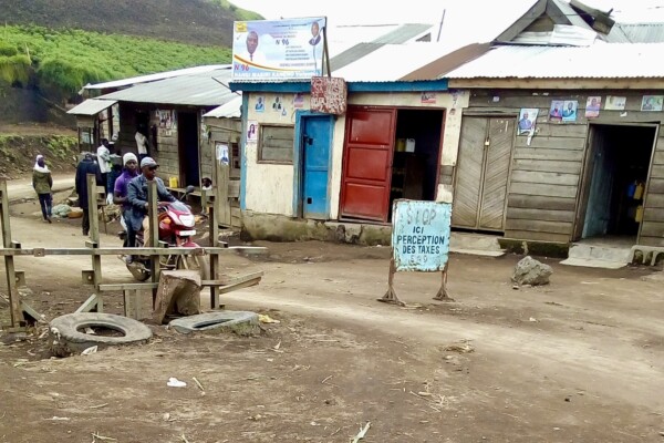
Roadblocks in Masisi and Walikale: Predation on movement in turbulent times
March 8, 2024While minerals have centered in research on conflict financing in the Democratic Republic of the Congo, armed actors often rely on alternative sources of revenue to finance their struggles. Among these are the operation of roadblocks. In this report, produced together with ASSODIP and the Danish Institute for International Studies, IPIS studies the linkage between roadblocks and the local artisana
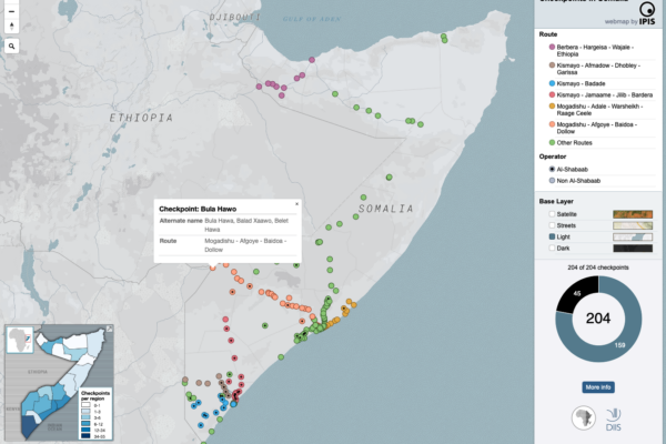
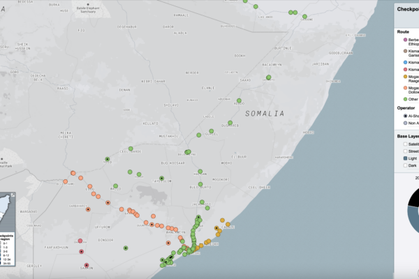
Mapping the political economy of checkpoints in Somalia
December 20, 2023The maps inform users on the locations of roadblocks across Somalia, the distribution of violence at checkpoints as well as the density of checkpoints per administrative region. Different maps also identify varying characteristics of the roadblocks, including their operator, location on a primary/secondary road and the amount paid at the checkpoint as toll.
Technical support for DIIS’ Somalia checkpoint mapping study
November 28, 2023Consultancy IPIS contributed to ‘Paying the Price: The Political Economy of Checkpoints in Somalia’ a project by the Danish Institute for International Studies (DIIS), the Rift Valley Institute (RVI) and XCEPT. IPIS supported the project by providing a frame for the project’s data collection, developing a questionnaire for project field researchers and a platform for the input and collation of the
Program for the Development of Eastern Congo (P-DEC)
January 11, 2022Eastern DRC continues to face complex crises rooted in conflicts around power, governance, identity and access to natural resources including minerals, land and forestry. The Program for the Development of Eastern Congo (P-DEC) adopts bottom-up peacebuilding approaches to reduce conflict and bridge social divisions. It supports communities and the private sector to:Build inclusive dialogue process
Checkpoint economy: the political economy of checkpoints in South Sudan, ten years after independence
December 10, 2021Ten years after independence, the world’s youngest country is home to an entrenched political economy of conflict premised on checkpoint taxation. Humanitarian aid is not exempt, reveals a major new mapping report by DIIS and IPIS. When South Sudan became independent ten years ago, oil revenues were supposed to fuel the economy of the world’s newest country. But two years later in 2013, oil prices
“The Blue Mine” as a new status for qualifying mine sites in DRC. The result of successful advocacy by the Madini Project
November 23, 2021On November 12th 2021, the National Minister of Mines of the Democratic Republic of Congo (DRC), Madam Antoinette N’Samba Kalambayi, signed the ministerial decree instituting a new status for the qualification /validation for artisanal mining sites: the Blue Status. Mine site qualification and validation (in line with the ICGLR’s Regional Certification Mechanism ) is a mandatory process in the DRC
Advocating for an improved enabling environment for the production, trade and export of OECD Due Diligence Guidance (DDG)-conformant minerals from eastern DRC
November 23, 2021As part of the Madini project, a review of the current situation, trends and barriers in the production, trade and export of tin, tantalum, tungsten (3T) and gold from eastern Democratic Republic of Congo (DRC) was conducted by Levin Sources, with the aim to recommend concrete actions that can improve OECD-conformant sourcing of these minerals from eastern DRC. The link between the exploitation of
Madini kwa Amani na Maendeleo – Minerals for Peace and Development
August 20, 2021In December 2019, IPIS joined the consortium of International Alert, EurAC, OGP and Justice Plus to implement the Madini kwa Amani na Maendeleo (Minerals for Peace and Development) project, which aims to improve security, social cohesion and human rights in the conflict-ridden mineral-rich regions of eastern DRC. To achieve this objective, the Madini project aims to contribute to local, provincial