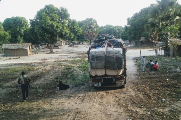
Promoting peaceful and seasonal migration in Northern Central African Republic
February 9, 2021“You can negotiate with an armed group, not with the drought” The borderlands of the Central African Republic (CAR) are home to one of the largest seasonal livestock migrations (transhumance) in the world. Decades of unrest and crisis, however, have brutally disrupted most aspects of herding—the routes taken, the people involved, governance mechanisms, as well as relations to local populations. To
Annual Report 2019
August 26, 2020This 2019 annual report provides an overview of IPIS’ research projects, capacity enhancement and outreach activities throughout last year. Read the full activity report to see what IPIS has been up to in 2019.
Conflict Mapping
August 25, 2020Maps have been critical tools in military logistics and understanding of conflict for centuries. During recent decades, advances in Geographical Information Systems (GIS) allow IPIS to use maps for even more sophisticated analysis of conflict and peacebuilding initiatives.By collecting first-hand information in remote and conflict-affected areas, IPIS developed a new approach to conflict mapping f
The political economy of roadblocks in South Sudan
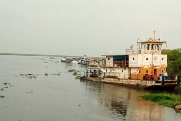
August 21, 2020Roadblocks are a structural feature of South Sudanese roads. Whereas roadblocks in principle have legitimate roles to fulfil — ensuring security and levying decentralized taxes — they can also become vehicles for insecurity and illegal taxation.Along South Sudanese roads and rivers, state agents, security forces as well as armed groups occupy checkpoints at which they levy illegal taxes and hamper
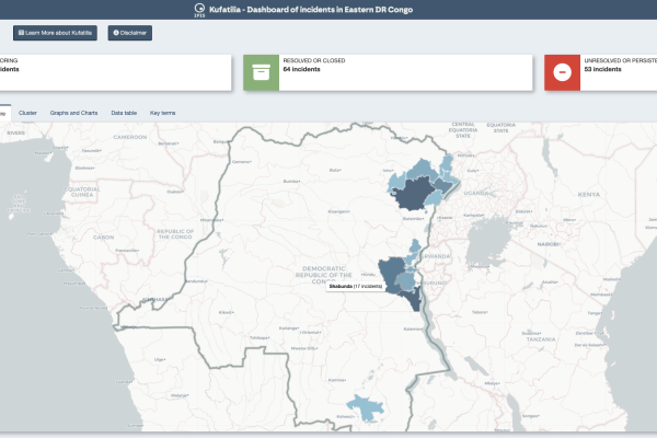
Dashboard of incidents in eastern DRC – Kufatilia
June 10, 2020The Kufatilia platform (“to track” in Swahili) is an SMS based incident reporting and follow-up mechanism that has been launched in 2019 to increase transparency of minerals supply chains in Eastern DRC. Developed by IPIS in partnership with the Centre for Expertise on Mining Governance (CEGEMI) based in Bukavu, and powered by Ulula, Kufatilia is a tool for Congolese civil society organisations to
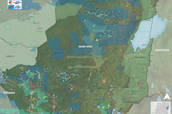
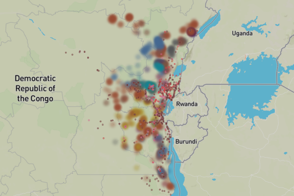
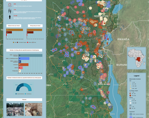
Maps of conflict minerals in Eastern DRC (2020)
June 9, 2020IPIS created maps of conflict minerals in eastern DRC, more particularly on Haut Uele, Ituri and North and South Kivu. These maps detail the type of minerals, the qualification of the mines, the mining titles and give an overview of armed presence in and around the mines. d Download the North Kivu map in full resolution Download the South Kivu map in full resolution Download the Haut
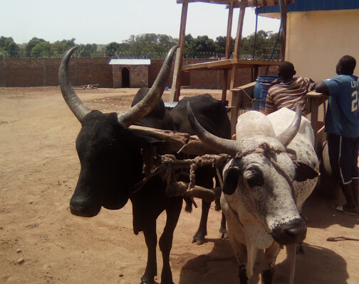
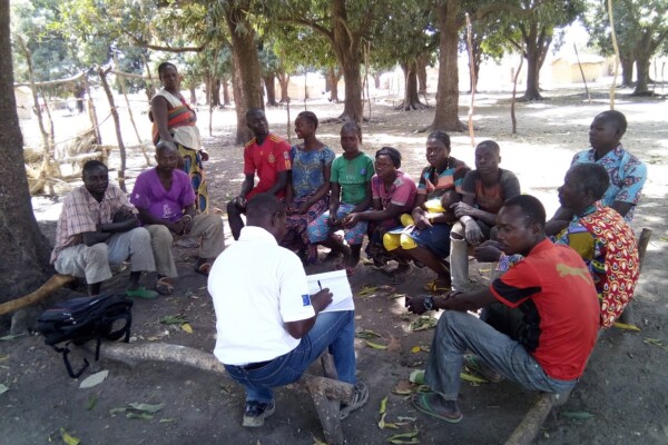
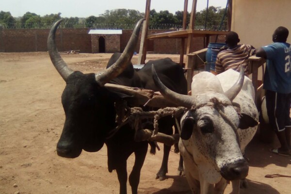
Pastoralism in the Central African Republic conflict
November 21, 2019IPIS engaged with the British NGO Concordis International in a 3-year mediation and peace building project on pastoralism in the Central African Republic (CAR). The research aims to enhance understanding of transnational transhumance conflict dynamics and to promote regional peace building measures.To avoid cattle thefts and taxes from the armed groups, pastoralists have deviated from the traditi
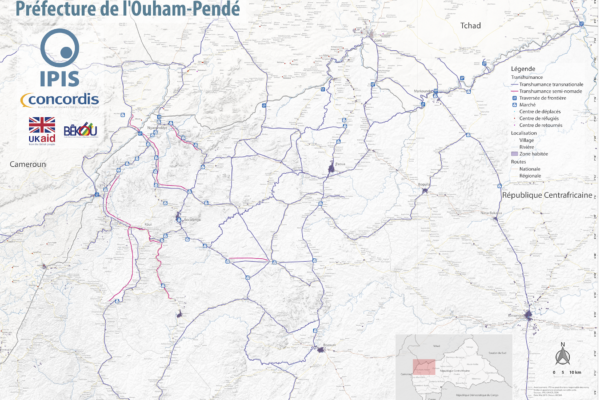
Map Pastoralism Ouham Pendé (2019)
September 12, 2019Each year the annual migration of transnational transhumance through the prefecture of Ouham-Pende, in northwestern Central African Republic (CAR), uproots a deep-seated mistrust between nomadic and sedentary communities. Escalating militancy and environmental pressures in the region has only amplified these issues in recent years.In partnership with Concordis International, IPIS hopes to enhance
IPIS welcomes University of Antwerp Summer School for workshop on artisanal diamond mining
September 2, 2019On August 28th, 2019, 21 students from the University of Antwerp’s ‘Mine to Finger’ Summer School on diamonds were engaged on “The use of digital maps and open data in the analysis of artisanal mining” with a case-study of the Central African Republic (CAR). The students, with diverse backgrounds, engaged in critical and nuanced discussions on artisanal diamond mining. The workshop kicked-off with
Annual Report 2018
June 27, 2019This 2018 annual report provides an overview of IPIS’ research projects, capacity enhancement and outreach activities throughout last year. IPIS consolidated its work in DRC, Central African Republic and Tanzania and deepened its expertise on mapping, data analysis and research on conflict drivers, natural resources, Business & Human Rights and arms trade. IPIS worked closely with civil societ
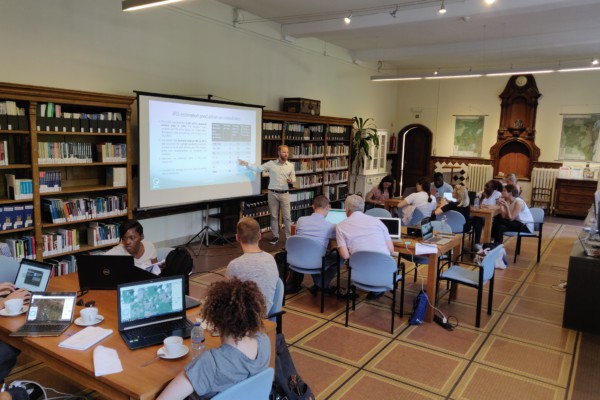
Working on conflict mapping through GIS – A goodbye from our latest GIS intern
May 29, 2019I arrived at IPIS in January of this year with the purpose to further improve my GIS skills and work on the topic of conflict mapping. Entering the IPIS premises and meeting the staff, my first impression of IPIS was that of a friendly and professional organization. They are lucky enough to be housed in an old monastery which seems like a small oasis in the middle of the loud and crowded city. Tha
Pastoralism in the Central African Republic conflict: new IPIS research launched
May 10, 2019With thorough conflict mapping and analysis of the drivers and actors of conflict in the Central African Republic, IPIS has contributed to a better understanding of the Central African Republic conflict. In 2019, IPIS will be focussing on one particular activity that generates conflict on the one hand, but is fundamental for strengthening peace on the other: Pastoralism. This research will t

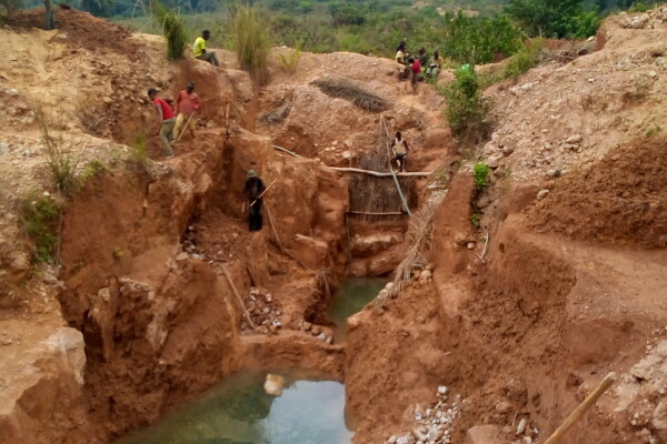
Mapping artisanal mining areas and mineral supply chains in eastern DRC (2019)
April 9, 2019In a new report and webmap, IPIS presents its updated data on armed conflict and armed interference in eastern DRC’s artisanal mining sector. Building on extensive data, gathered over the last ten years, IPIS assesses the impact of responsible sourcing initiatives in DRC, designed to address armed interference in mineral supply chains. The report illustrates that responsible sourcing efforts have
Conflict mapping in eastern DRC
April 3, 2019Related Publication(s) Maps of artisanal and small-scale mining in eastern DRC Maps of conflict minerals in Eastern DRC (2020) Conflict Minerals in Eastern DRC (2017) Mineral supply chains and conflict links in eastern democratic republic of congo Mapping Conflict Minerals (2012) Mapping Conflict Motives: M23 (2012) Violence against women in Eastern Democratic Republic of Congo. Whose responsibili
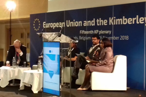
Kimberley Process Civil Society Coalition calls on all Members to deliver on improving global diamond governance
November 14, 2018Reform is high on the agenda of this year’s Kimberley Process Plenary under EU Chairmanship. The Kimberley Process – once a pioneering tripartite effort to stop diamonds from financing rebel groups – is struggling to provide an adequate answer to numerous human rights challenges associated with the diamond sector today. Aware of these enormous challenges, it was decided at the 2017 Plenary meeting
22 November – IPIS panel discussion on the Central African Republic
October 19, 2018Central African Republic: A Conflict Mapping IPIS kindly invites you to a panel discussion on the conflict in the Central African Republic on Thursday November 22, 4:30pm at the Jacqmotte Conference Center, Hoogstraat/Rue Haute 139 in Brussels. Please register at events@ipisresearch.be Programme 4:30 – Welcome Honorary Ambassador Johan Swinnen, Chair IPIS 4:40 – Keynote speech
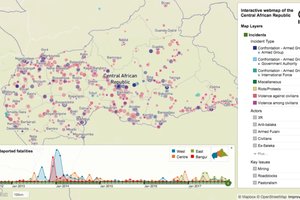
Conflict mapping in the Central African Republic
October 3, 2018News 22 November – IPIS panel discussion on the Central African Republic October 19, 2018 Central African Republic: A Conflict Mapping IPIS kindly invites you to a panel discussion on the conflict in the Central African Republic on Thursday November 22, 4:30pm at the Jacqmotte Roadblock rebels: IPIS maps important mechanism of conflict funding in Central AfricaDecember 6, 2017 IPIS puts
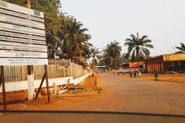
Article – The Political Economy of Roadblocks in the Central African Republic
October 2, 2018From September 2016 to September 2017, the International Peace Information Service (IPIS) and the Danish Institute for International Studies (DIIS) conducted a mapping of roadblocks in the Central African Republic. This data collection campaign also features more than 200 interviews with various actors and was combined with data from other reports on roadblocks to form a comprehensive study on the

Central African Republic – Ouham-Pende Basemap (2019)
September 17, 2018Each year the annual migration of transnational transhumance through the prefecture of Ouham-Pende, in northwestern Central African Republic (CAR), uproots a deep-seated mistrust between nomadic and sedentary communities. Escalating militancy and environmental pressures in the region has only amplified these issues in recent years. These maps, created by IPIS, detail the towns, villages, roads, ID
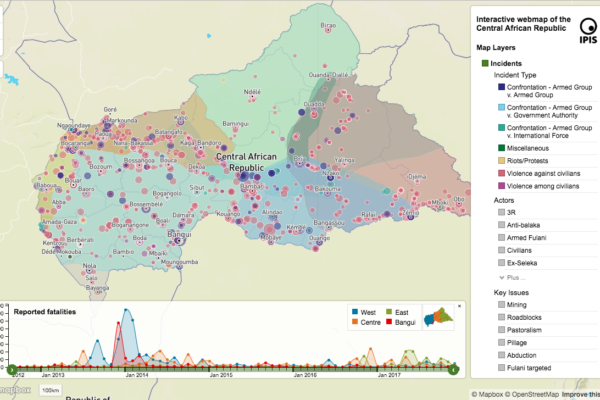
Central African Republic: A Conflict Mapping (2018)
September 16, 2018In a new report and webmap on the longstanding crisis in the Central African Republic (CAR), IPIS points out that access to resources remains the predominant driver of both armament and conflict in CAR. All armed groups operating in CAR are engaged in predation on one or more economic sectors. Such predation is not only a key determinant of an armed group’s movements and activities, but prov