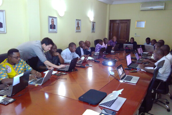
Capacity enhancement workshop on cartography with DRC mining authorities
May 16, 2017Capacity enhancement workshop on cartography with DRC mining authorities In the framework of its long standing partnership with DRC mining authorities, IPIS held a workshop in Kinshasa from May 8th to 12th, engaging with technical staff of ‘Cadastre Minier’, ‘SAESSCAM’ and ‘Division des mines’. The workshop focussed on Open Source solutions for mapping and web-mapping, such as ‘QGIS’ and ‘qgis2web
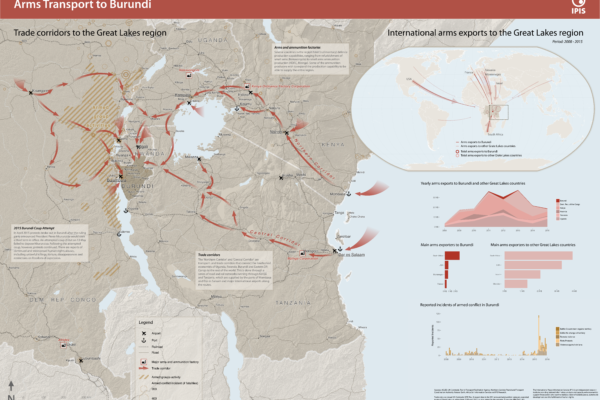
Arms Trade Corridors to Burundi
May 5, 2017Burundi has seen a period of unrest following the failed coup d’état by a Burundian general in May 2015. In order to better understand the situation, IPIS drafted a new map entitled ‘Arms transport to Burundi’, which puts the 2015 unrest in the geographical perspective of the Great Lakes region and in the relevant timeframe covering 2008 to 2015. The map highlights two important factors in the rec
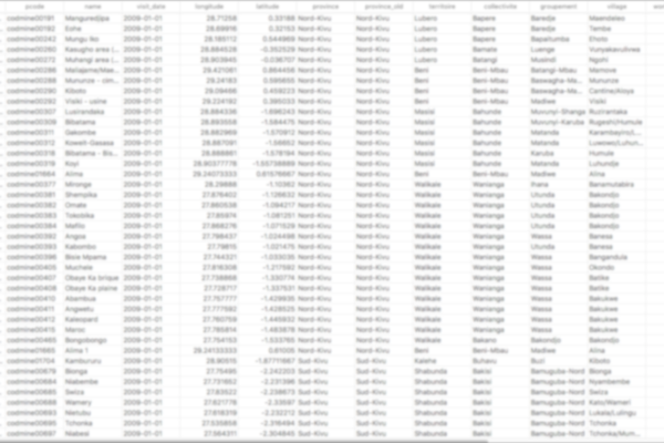
IPIS opens up its data!
May 2, 2017Data collection on peace, development and human rights is an essential part of the research work we do at IPIS. Because we believe in the power of Open Data to stimulate research that contributes to our vision of durable peace, sustainable development and the fulfilment of human rights, we are happy to announce that we are now providing structured access to some of our key datasets. Our data colle
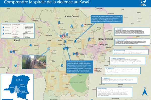
Comprendre la spirale de la violence au Kasaï (2017)
April 25, 2017Le Kasaï Central et trois autres provinces voisines sont en proie à des violences mêlant miliciens, policiers et soldats et ayant fait, selon un rapport récent des Nations Unies, plus de 200 morts. Depuis septembre, un soulèvement des partisans du chef coutumier Kamwina Nsapu, tué en août par les forces de l’ordre après s’être rebellé contre les autorités congolaises, a embrasé la région. L’ONU a
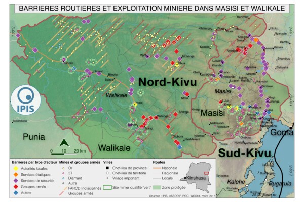
Pillage route: l’économie politique des barrages routiers à Walikale et Masisi (2017)
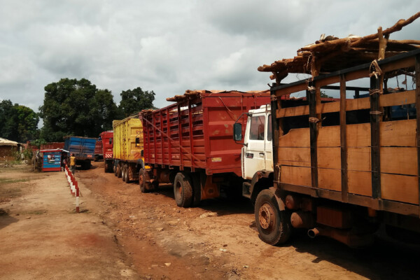
March 31, 2017French version below – version française ci-dessous Roadblocks are a ubiquitous phenomenon in Eastern Congo. In an effort to map the scope of this phenomenon as well as its significance in the political economy of conflict, IPIS has embarked on a collaboration with the Danish Institute for International Studies. The point of departure is that control over the circulation of people and valua

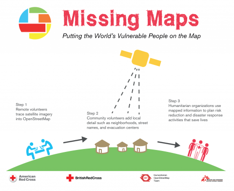
IPIS hosts new Missing Maps Mapathon with special focus on DRC National Parks
March 30, 2017IPIS, Missing Maps and OpenStreetMap Belgium organise another Missing Maps Mapathon on Wednesday April 26, in the IPIS library. Why do we organise this? NGOs working in the South need decent maps in order to reach people who need help. However, in many places the map is not yet complete. That’s why we need your help! How do we help? We teach volunteers how to trace satellite imagery
Open data
March 20, 2017Please note:Due to a migration to a new database provider, we are currently reworking the open data page. While our previous geoserver is offline, you may access our open datasets on the artisanal mining sector through the following direct downloads: DR Congo Central African Republic Welcome to the IPIS Open Data page. IPIS publishes a growing number of datasets as Open Data. Here, you can find ou
Het conflict in de Centraal-Afrikaanse Republiek
January 27, 2017In 2014 deed IPIS een uitgebreid ‘conflict mapping’ onderzoek om inzicht te krijgen in de veiligheidssituatie in de Centraal-Afrikaanse Republiek (CAR). Dit leidde tot de publicatie van een publiek toegankelijke webkaart over belangrijke conflictdynamieken. IPIS bracht de gewapende groepen, mensenrechtenschendingen, natuurlijke rijkdommen, vluchtelingenstromen en migratieroutes van veehouders in k
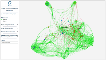
Presentation of Gephi, an open source network visualisation tool
November 14, 2016During the GeONG 2016 conference organised by CartONG in Chambery from 17th to 19th October, IPIS researcher AlexandreJaillon animated a workshop on Gephi, an open-source network visualisation tool, used by IPIS to display power relationships between key stakeholders in Eastern DRC. IPIS uses Gephi, an interactive network visualisation tool, to map and visualize power dynamics in and post-conflict
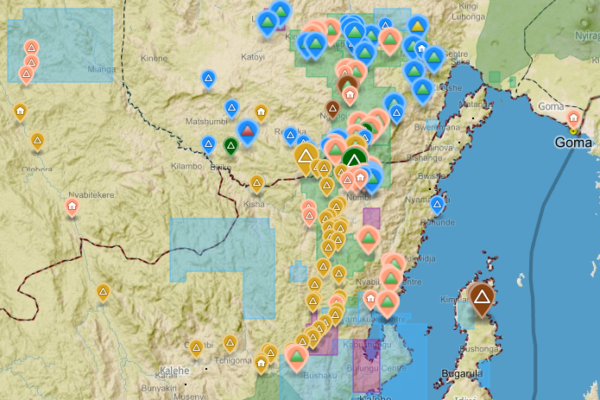
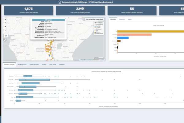
Analysis of the interactive map of artisanal mining areas in eastern DR Congo – 2015 update
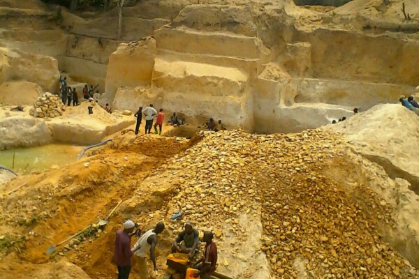
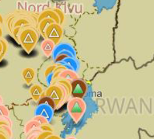
October 25, 2016The Belgian research group IPIS has collected data on 2026 artisanal mining sites in eastern DRC over the last couple of years. IPIS observed an armed presence in more than half of the mines. In an interactive map, updated in 2015, IPIS provides information about the on-site presence of armed groups and the Congolese army (FARDC) as well as indicators of the relative importance of the site. It als
Missing Maps Mapathon / Wednesday, 26 October 2016
October 4, 2016IPIS, Missing Maps and OpenStreetMap Belgium organise another Missing Maps MAPATHON on Wednesday October 26, at the IPIS library! IPIS Research and Openstreetmap Belgium invite you to come map for the Missing Maps project with us. By doing so, you will learn how to create the open maps that make the work of NGOs like Doctors Without Borders or IPIS Research easier. After the event, you will be abl
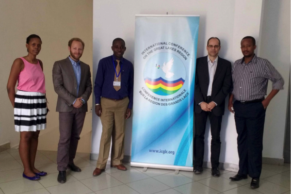
Design of the ICGLR regional database on mineral flows
September 6, 2016The Executive Secretariat of the International Conference on the Great Lakes Region (ICGLR), with the financial support of Partnership Africa Canada (PAC), has commissioned a consultancy to design the architecture of the ICGLR Regional Database on mineral flows, one of the six tools of the Regional Initiative on Natural Resources (Lusaka declaration). Estelle Levin Ltd. (ELL) and the International
Annual Report 2015
August 31, 2016Download pdf or open with issuu reader http://issuu.com/ipisresearch/docs/2016_10_10_ipis_jaarverslag_2015_20

Missing Maps mapathon / Wednesday, 29 June 2016
June 8, 2016IPIS, Missing Maps and OpenStreetMap Belgium organise another Missing Maps MAPATHON on Wednesday, June 29, at the IPIS library! IPIS Research and Openstreetmap Belgium invite you to come map for the Missing Maps project with us. By doing so, you will learn how to create the open maps that make the work of NGOs like Doctors Without Borders or IPIS Research easier. After the event, you will be able
Accessible and Interactive: New Methods of Data Visualization as Tools for Data Analysis and Information Sharing in Transitional Justice Research
March 24, 2016Abstract The production and use of datasets is a growing area in transitional justice research. One constant limitation, however, is the way this data is visualized. Relying only on static graphics and tables, many of these datasets are insufficiently explored and analyzed, and remain inaccessible for other researchers. Interactive data visualization tools are an ideal method for overcoming this g
Missing Maps mapathon / Wednesday, 23 March 2016
February 17, 2016IPIS, Missing Maps and OpenStreetMap Belgium organise the mapping event ‘Missing Maps mapathon’ on Wednesday March 23 at the IPIS library! IPIS Research and Openstreetmap Belgium invite you to come map for the Missing Maps project with us. Doing so, you will learn how to create the open maps that make the work of NGOs like Doctors Without Borders or IPIS Research easier. After the event, you will
Mineral supply chains and conflict links in eastern democratic republic of congo
November 25, 2015Between 2009 and 2010 IPIS collected data on over 550 mining sites as part a conflict mapping exercise focusing on Eastern Democratic Republic of Congo (DRC). With the collaboration of Congolese researchers, IPIS collected the coordinates of the most important mining sites and information on on-site security in North and South Kivu provinces, Maniema, Northern Katanga and southeast Province Orient
COMING SOON! Missing Maps mapathon / Wednesday, 9 December 2015
November 12, 2015IPIS, Missing Maps and OpenStreetMap Belgium organise the mapping event ‘Missing Maps mapathon’ on Wednesday December 9th at the IPIS library! The Missing Maps project is an open collaboration between the Humanitarian OpenStreetMap Team (HOT), Doctors without Borders UK, and the British and American Red Cross. The goal of the project is to map the areas of the world that are the most sensitive to
Infographic – Mapping conflict motives in the CAR
January 28, 2015