I arrived at IPIS in January of this year with the purpose to further improve my GIS skills and work on the topic of conflict mapping. Entering the IPIS premises and meeting the staff, my first impression of IPIS was that of a friendly and professional organization. They are lucky enough to be housed in an old monastery which seems like a small oasis in the middle of the loud and crowded city. That quiet place reminded me of the summer holidays I spent in a monastery on Croatian coast.
 The GIS team quickly included me in their workflow. I performed a variety of tasks ranging from data management, data cleaning and data processing to map making. This allowed me to get to know the internal data structure and workflows, to which the team caringly introduced me. I gained experience with Excel Pivot tables for summarizing and representing data, deepened my SQL experience for automating tasks, was introduced to Mobile Data Collection technologies such as ODK and Kobo and learned to use QGIS and R.
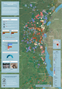
Like every GIS intern at IPIS, I was given one ‘major’ task on which I could work for quite some time. In my case, it was to make a map of DRCongo that visualizes artisanal mining sites and the surrounding zones controlled by different armed groups. Given the size of the map and the amount of additional auxiliary map elements, it was quite an undertaking which allowed me to upgrade my QGIS skills.
Next, I was given the opportunity to learn a data visualisation tool called D3JS, which is used to create interactive charts of data. I wrote the code in JavaScript for some new interactive charts, which were later embedded in one of IPIS’ interactive maps.
I performed a wide range of tasks at IPIS which were really at the core of their projects and research. When I did have some free time between different tasks, I was given the freedom to learn new things and do exercises which were useful for both the organization’s and my own development. Also, after my hours I worked on and finished my master thesis, which is also on the topic of conflict mapping. I was glad to be able to finish my internship presenting this work to the team.
All in all, I can say that this was a very valuable experience for me where I have learned a lot of new skills. On this occasion, I would like to thank everyone at IPIS, especially the GIS team Alexandre and Manuel, who spent a lot of time with me patiently reviewing the results of my assignments and giving me positive feedback.
— Franjo
Interested in joining IPIS as a GIS intern? IPIS will be looking for a GIS intern for the fall semester 2019. The recruitment will start approx. in July/August. More information here.