
Publications
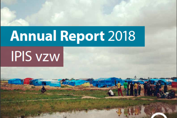
Annual Report 2018
- IPIS | 27 juin 2019
This 2018 annual report provides an overview of IPIS’ research projects, capacity enhancement and outreach activities throughout last year. IPIS consolidated its work in DRC, Central African Republic and Tanzania and deepened its expertise on mapping, data analysis and research on conflict drivers, natural resources, Business & Human Rights and arms trade. IPIS worked closely with civil societ

Cartographie des zones minières artisanales et des chaînes d’approvisionnement en minéraux dans l’est de la RDC
- Ken Matthysen, Peer Schouten (DIIS/IPIS), Steven Spittaels | 22 avril 2019
Dans son dernier rapport et sa dernière webmap, IPIS présente ses données actualisées sur l’impact des conflits armés et de l’ingérence des groupes armés dans le secteur minier artisanal dans l’est de la République Démocratique du Congo. En s’appuyant sur une vaste base de données collectées sur les dix dernières années, IPIS évalue l’impact des initiatives d’approvisionnement responsables qui vis
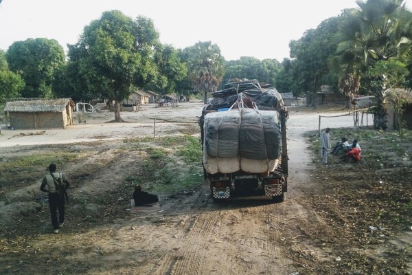
Article – The Political Economy of Roadblocks in the Central African Republic
- Alexandre Jaillon, Peer Schouten (DIIS/IPIS), Soleil Kalessopo | 2 octobre 2018
From September 2016 to September 2017, the International Peace Information Service (IPIS) and the Danish Institute for International Studies (DIIS) conducted a mapping of roadblocks in the Central African Republic. This data collection campaign also features more than 200 interviews with various actors and was combined with data from other reports on roadblocks to form a comprehensive study on the

Central African Republic – Ouham-Pende Basemap (2019)
- Alexandre Jaillon, Emily Doerner | 17 septembre 2018
Each year the annual migration of transnational transhumance through the prefecture of Ouham-Pende, in northwestern Central African Republic (CAR), uproots a deep-seated mistrust between nomadic and sedentary communities. Escalating militancy and environmental pressures in the region has only amplified these issues in recent years. These maps, created by IPIS, detail the towns, villages, roads, ID
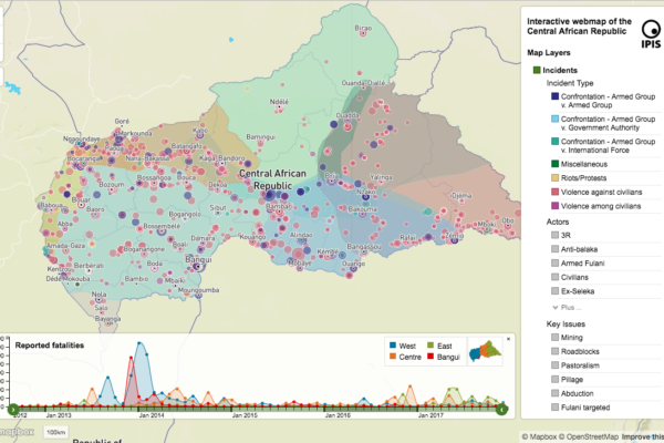
République centrafricaine: cartographie du conflit
- IPIS | 16 septembre 2018
Dans un nouveau rapport et une nouvelle carte web sur la crise en République centrafricaine (RCA), IPIS souligne que l’accès aux ressources reste le principal moteur de l’armement et des conflits en RCA. Tous les groupes armés opérant en RCA se livrent à la prédation sur un ou plusieurs secteurs économiques. Une telle prédation est non seulement un facteur déterminant des mouvements et des activit
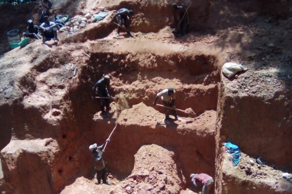
Annual Report 2017
- IPIS | 21 août 2018
In its 2017 annual report, IPIS gives an overview of its research projects and activities. It covers the four research programmes that IPIS focusses on: natural resources, arms trade, conflict mapping and business and human rights. IPIS explains among others its mapping work of artisanal mining sites in the Democratic Republic of Congo, its work on Human Rights in mining in Northwest Tanzania an
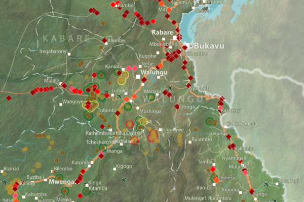
Barrières routières et sites miniers artisanaux – Provinces du Nord- et du Sud-Kivu (2018)
- Maryam Zarkeyvan | 20 mars 2018
Cette carte montre l’emplacement des barrières routières et des sites miniers artisanaux dans les provinces du Kivu. Elle a été créé en combinant les jeux données de notre rapport récent sur les barrières routières dans la région, et de la récente mise à jour de notre base de données et notre carte interactive sur les sites miniers artisanaux dans l’est de la RDC. Téléchargez la carte

Interactive map of artisanal mining exploitation in eastern DR Congo – 2018 update
- Ken Matthysen | 19 mars 2018
Résumé français ci-dessous – French summary below IPIS launched a major update of it’s DRC webmap displaying data on more than 2400 artisanal mining sites in eastern DRC and more than 800 roadblocks. Since December 2016, IPIS teams have visited more than 500 artisanal mines in eastern DRC, gathering data that has been added to IPIS’ interactive webmap. IPIS also integrated other datasets gathered
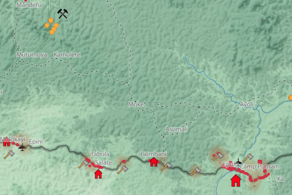
Okapi Wildlife Reserve: Illegal Sourcing of Gold and Timber (2018)
- Manuel Claeys Bouuaert, Maryam Zarkeyvan | 1 février 2018
A map of the Okapi Wildlife Reserve in DRC, created as a result of two mapathons focussing on illegal activities in the park.
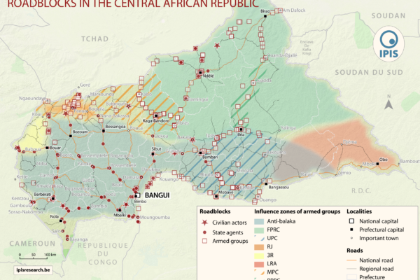
« Laissez-piller » L’économie politique des barrières routières en République centrafricaine
- Alexandre Jaillon, Peer Schouten (DIIS/IPIS), Soleil Kalessopo | 7 décembre 2017
IPIS, l’institut belge de recherche, dresse la carte des barrages routiers et pointe leur rôle clé dans les mécanismes de financement des conflits en Afrique centrale et des acteurs armés en République démocratique du Congo(RDC) et en République centrafricaine. Deux rapports de IPIS révèlent l’étendue de l’emprise des acteurs armés sur les routes commerciales en Afrique centrale, une région en pr
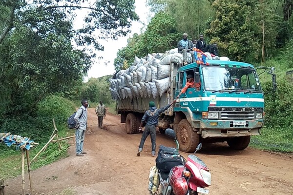
« Tout ce qui bouge sera taxé » : l’économie politique des barrières routières au Nord et Sud Kivu
- Alexandre Jaillon, Janvier Murairi, Peer Schouten (DIIS/IPIS), Saidi Kubuya (ASSODIP) | 6 décembre 2017
IPIS dresse la carte des barrages routiers et pointe leur rôle clé dans les mécanismes de financement des conflits en Afrique centrale et des acteurs armés en République démocratique du Congo (RDC) et en République centrafricaine. Deux rapports de IPIS révèlent l’étendue de l’emprise des acteurs armés sur les routes commerciales en Afrique centrale, une région en proie aux conflits. IPIS a consta
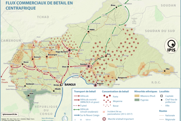
Pastoralism corridors in Central African Republic (2017)
- Alexandre Jaillon, Milan Nublat | 1 décembre 2017
While pastoralism can generates wealth and economic interdependence between farmers and cattle herders, it can also causes tension and conflicts. In the current Central African Republic crisis context, transnational livestock migrations, particularly by Chadian and Sudanese herdsmen to CAR, have led to clashes between pastoralists and the local population. IPIS has developed a map showing the main

Towards a multi-scale approach for an Earth observation based assessment of natural resource exploitation in conflict regions
- Elisabeth Shoepfer et al., Filip Hilgert | 6 novembre 2017
Environment and natural resources can be key elements in starting and fueling conflicts. IPIS researcher Filip Hilgert contributed to an article in Geocarto International (2017, vol. 32, n° 10) on a multi-scale approach for an Earth observation based assessment of natural resource exploitation in conflict regions. Download the full article Elisabeth Schoepfer, Kristin Spröhnle, Olaf Kranz, Xavier
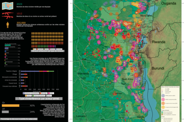
Conflict Minerals in Eastern DRC (2017)
- Alexandre Jaillon | 22 septembre 2017
Printing maps of conflict minerals in Eastern DRC.
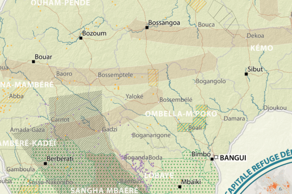
République Centrafricaine: Portait d’un territoire riche en crises (2012 – 2017)
- Alexandre Jaillon, Milan Nublat | 19 septembre 2017
This poster is a compilation of maps and graphics related to the situation in the Central African Republic. A map of natural resources and poaching corridors presents the known wealth of this country, often considered as conflict drivers in the absence of well functioning state authorities. A small map presents the current armed groups area of influence as well as the number of reported violent in
Annual report 2016
- IPIS | 23 juin 2017
In its 2016 annual report, IPIS gives an overview of its research projects and activities. It covers the four research programmes that IPIS focusses on: natural resources, arms trade, conflict mapping and business and human rights. In 2016, IPIS continued to be a rally point for hard to get data on natural resources, often visualised in maps. Our flagship map for 2016 is the interactive map of art
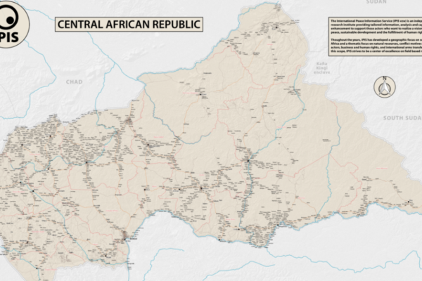
Central African Republic – Road Map (2017)
- Alexandre Jaillon, Milan Nublat | 1 juin 2017
In 2013 the Central African Republic entered a period of great instability. The predominantly Muslim rebel coalition, Seleka, seized power. A group of mostly Christian militias, the Anti-balaka, rose up to counter the Seleka. Years of atrocities, horrors and fighting followed. In 2016 a democratic election was held, a sign of hope for the people of the CAR. However, dissolved fractions of the Sele
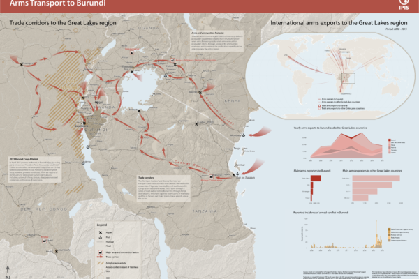
Arms Trade Corridors to Burundi
- IPIS | 5 mai 2017
Burundi has seen a period of unrest following the failed coup d’état by a Burundian general in May 2015. In order to better understand the situation, IPIS drafted a new map entitled ‘Arms transport to Burundi’, which puts the 2015 unrest in the geographical perspective of the Great Lakes region and in the relevant timeframe covering 2008 to 2015. The map highlights two important factors in the rec
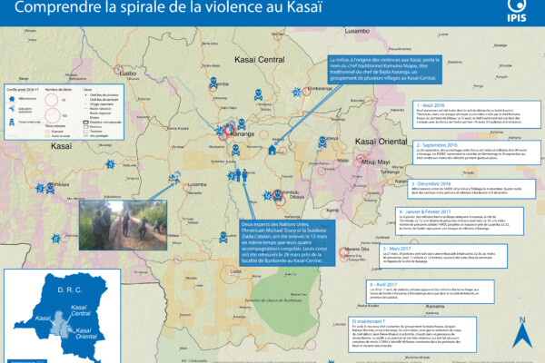
Comprendre la spirale de la violence au Kasaï (2017)
- Alexandre Jaillon | 25 avril 2017
Le Kasaï Central et trois autres provinces voisines sont en proie à des violences mêlant miliciens, policiers et soldats et ayant fait, selon un rapport récent des Nations Unies, plus de 200 morts. Depuis septembre, un soulèvement des partisans du chef coutumier Kamwina Nsapu, tué en août par les forces de l’ordre après s’être rebellé contre les autorités congolaises, a embrasé la région. L’ONU a
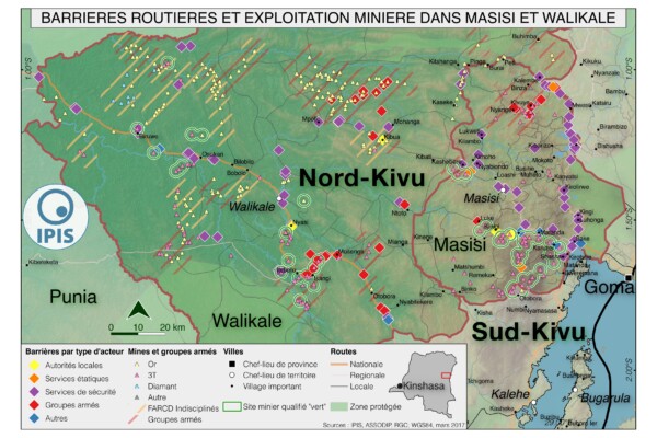
Pillage route: l’économie politique des barrages routiers à Walikale et Masisi (2017)
- Alexandre Jaillon, IPIS, Janvier Murairi, Peer Schouten (DIIS/IPIS), Saidi Kubuya Batundi | 31 mars 2017
French version below – version française ci-dessous Roadblocks are a ubiquitous phenomenon in Eastern Congo. In an effort to map the scope of this phenomenon as well as its significance in the political economy of conflict, IPIS has embarked on a collaboration with the Danish Institute for International Studies. The point of departure is that control over the circulation of people and valua