Ground-based incident reporting in Eastern DRC – Progress Report 1
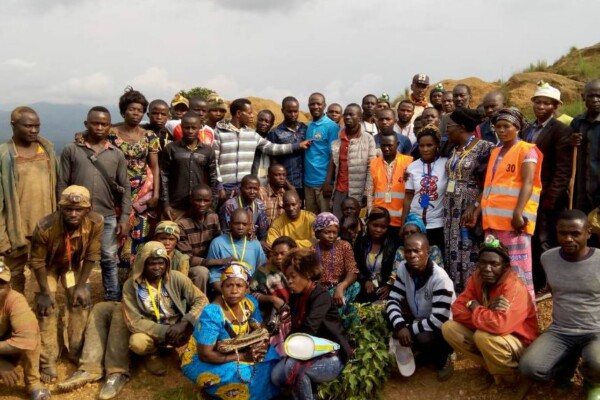
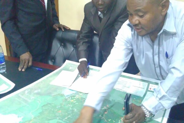
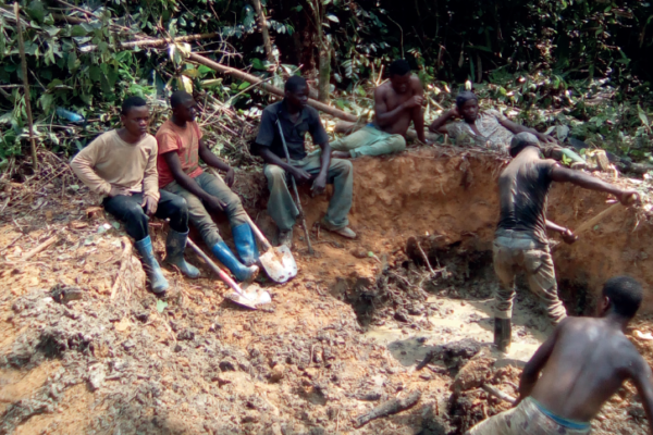
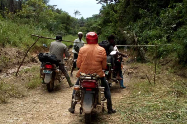
July 23, 2018In January 2018, IPIS and its partner CEGEMI (a Bukavu-based research institute) launched a two-year project founded by EPRM to advance incident reporting and community participation in responsible sourcing through cooperative and CSO capacity enhancement in Eastern DR Congo gold sector. “First field visit to identify potential cooperative to be part of project activities.” Copyright: Gabriel KAMU
Voix du Congo: Fraud and mineral smuggling in the territory of Kalehe, South Kivu
April 15, 2018See our series: VOIX DU CONGO This publication, by the “Centre National d’Appui au Développement et à la Participation Populaire” (CENADEP), presents a study on the channels of mineral fraud and smuggling in Kalehe (South Kivu) and, more specifically, the case of the Numbi/Lumbishi supply chain. In Kalehe territory, Numbi’s supply chain is one of the most important because it can produ
Voix du Congo: Taxation and parafiscality in artisanal mining in Tanganyika, DRC
April 5, 2018See our series: VOIX DU CONGO This publication, by the non-profit organization “Commission Diocésaine Justice et Paix” (CDJP Kalemie-Kirungu), presents a study on the legal and illegal taxation of artisanal mining activities by various actors in the province of Tanganyika, DRC. Artisanal mining is an activity that employs several thousand people in Tanganyika. Despite a 2002 law aiming at o
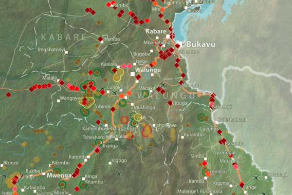
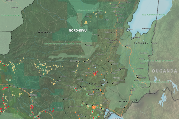
Roadblocks and artisanal mining sites – North and South Kivu Provinces (2018)
March 20, 2018This map show the location of roadblocks and artisanal mining sites in the Kivu provinces. It was made by combining data from our recent report on roadblocks in the area, and data from our recent update of our database and webmap on artisanal mining sites in eastern DRC. Download the full image

Interactive map of artisanal mining exploitation in eastern DR Congo – 2018 update
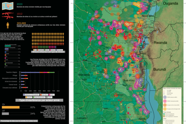
March 19, 2018Résumé français ci-dessous – French summary below IPIS launched a major update of it’s DRC webmap displaying data on more than 2400 artisanal mining sites in eastern DRC and more than 800 roadblocks. Since December 2016, IPIS teams have visited more than 500 artisanal mines in eastern DRC, gathering data that has been added to IPIS’ interactive webmap. IPIS also integrated other datasets gathered
Training and workshop on mapping artisanal mining in Eastern DRC
February 9, 2018(French version below) 2373 Mining sites visited, including 470 visits in the last thirteen months. 300 Roadblocks visited on a total of 798 mapped roadblocks. More than 18 000 km travelled by plane, bus, motorbikes and by foot… These are a few of the impressive results achieved by the twelve IPIS researchers in Eastern DRC. Late January, a workshop held in Goma gave IPIS researchers an opportun
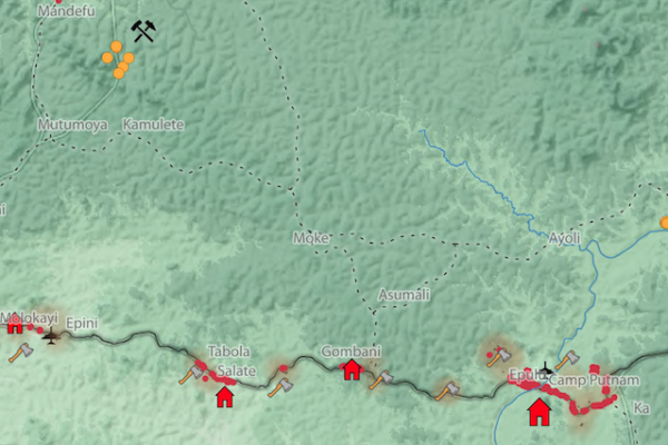
Okapi Wildlife Reserve: Illegal Sourcing of Gold and Timber (2018)
February 1, 2018A map of the Okapi Wildlife Reserve in DRC, created as a result of two mapathons focussing on illegal activities in the park.
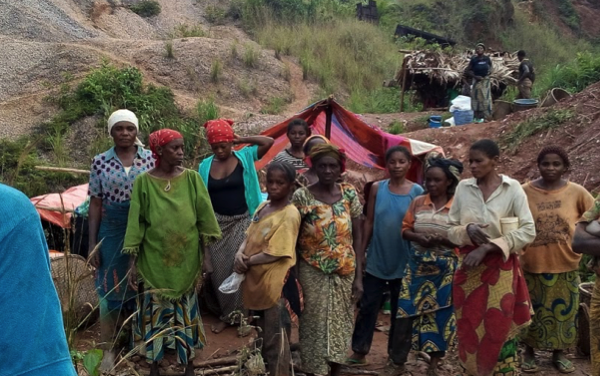
Voix du Congo: The place of women in artisanal mining in the Masisi territory: Legislation and field practice
December 21, 2017See our series : VOIX DU CONGO This publication, by the non-profit organisation “Action pour la Liberté et le Développement des Communautés Locales” ALDECO, presents a research on 3T artisanal mining in the Masisi territory and the Rubaya mining site in North Kivu (DRC). The goal is to understand what place is reserved for women in this field. This article helps understanding whether international
“Everything that moves will be taxed”: the political economy of roadblocks in North and South Kivu (2017)
December 6, 2017IPIS puts roadblocks on the map as key mechanism of conflict funding besides natural resources, revealing its devastating scope in funding armed actors in Democratic Republic of Congo and Central African Republic Mapping over a thousand roadblocks, IPIS shows the shocking extent of armed predation on trade routes in conflict-ridden Central Africa. Roadblocks, IPIS claims, have netted armed groups

Towards a multi-scale approach for an Earth observation based assessment of natural resource exploitation in conflict regions
November 6, 2017Environment and natural resources can be key elements in starting and fueling conflicts. IPIS researcher Filip Hilgert contributed to an article in Geocarto International (2017, vol. 32, n° 10) on a multi-scale approach for an Earth observation based assessment of natural resource exploitation in conflict regions. Download the full article Elisabeth Schoepfer, Kristin Spröhnle, Olaf Kranz, Xavier
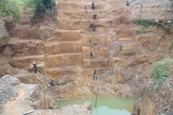
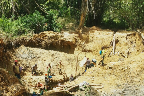
Artisanal Gold Monitoring Pilot (2017)
October 17, 2017With the support of the Public Private Alliance for Responsible Minerals Trade (PPA), IPIS set up its Artisanal Gold Monitoring Pilot in Mambasa (Ituri Province, DRC) between April 2016 and July 2017. This involved developing a low-cost methodology to produce a continuous data flow on a wide range of indicators related to the operational, security and human rights context of artisanal gold mining.
Conflict Minerals in Eastern DRC (2017)
September 22, 2017Printing maps of conflict minerals in Eastern DRC.
Maps of Mining Sites in North Kivu (2017)
September 21, 2017North Kivu Province – AO Map Lubero, Oicha, Butembo and Beni Territories – A0 Map Masisi Territory – A0 Map Masisi Territory, North Kivu Province, DRC Masisi Territory, North Kivu Province, DRC (Detail) Rutshuru Territory – A0 Map Rutshuru Territory, North Kivu Province, DRC Rutshuru Territory, North Kivu Province, DRC (Detail) Walikale Territory – A0 Map Walikal
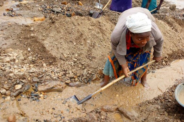
Voix du Congo: Study on the use of mercury and cyanide in artisanal gold mining in North and South Kivu
July 7, 2017See our series: VOIX DU CONGO This publication, by “Save Act Mine” SAM, presents a study on gold mining techniques in Eastern DRC. In these regions, the subsoil is very rich in minerals. Although this represents enormous potential for the economy, it also leads to particularly dangerous challenges such as environmental pollution and the degradation of the health status of local populations
Voix du Congo: Artisanal miners and surrounding communities, victims of the security and justice services in South Kivu, eastern DRC
July 7, 2017See our series: VOIX DU CONGO This publication, by the non-profit organisation “Association Africaine de Défense des Droits de l’Homme” ASADHO, focuses on human rights violations carried out by members of the DRC’s armed forces in the mining sector in the South Kivu Province. Several violations are regularly committed by the Congolese armed forces, either in operation or when deploye
Voix du Congo: Sexual exploitation of underage girls in the mining areas of South Kivu province in the Democratic Republic of Congo
July 7, 2017See our series VOIX DU CONGO This publication, by the non-profit association “Centre pour l’Education, Animation et Défense des Droits de l’Homme” CEADHO, presents a research on the sexual exploitation of underage girls in mining areas in South Kivu. The sexual exploitation of underage girls in mining areas is an increasingly recurrent phenomenon in South Kivu and is taking on a more w
Artisanal Gold Monitoring Pilot – Progress reports
June 20, 2017With the support of the Public Private Alliance for Responsible Minerals Trade (PPA), IPIS set up its Artisanal Gold Monitoring Pilot in Mambasa (Ituri Province, DRC) between April 2016 and July 2017. The findings of the research are summarized in three progress reports, which can be found below, and a final monitoring report, which can be found here. Progress report August – September 2016
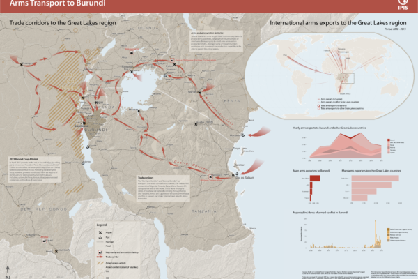
Arms Trade Corridors to Burundi
May 5, 2017Burundi has seen a period of unrest following the failed coup d’état by a Burundian general in May 2015. In order to better understand the situation, IPIS drafted a new map entitled ‘Arms transport to Burundi’, which puts the 2015 unrest in the geographical perspective of the Great Lakes region and in the relevant timeframe covering 2008 to 2015. The map highlights two important factors in the rec
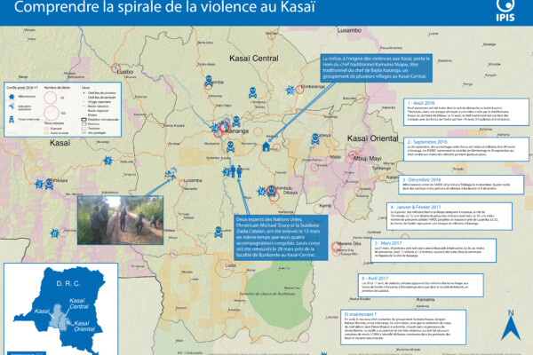
Comprendre la spirale de la violence au Kasaï (2017)
April 25, 2017Le Kasaï Central et trois autres provinces voisines sont en proie à des violences mêlant miliciens, policiers et soldats et ayant fait, selon un rapport récent des Nations Unies, plus de 200 morts. Depuis septembre, un soulèvement des partisans du chef coutumier Kamwina Nsapu, tué en août par les forces de l’ordre après s’être rebellé contre les autorités congolaises, a embrasé la région. L’ONU a
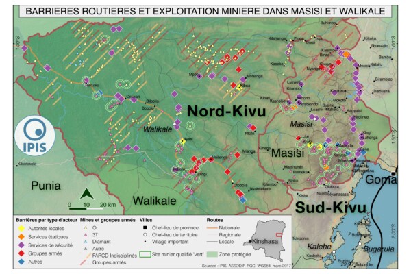
Pillage route: l’économie politique des barrages routiers à Walikale et Masisi (2017)
March 31, 2017French version below – version française ci-dessous Roadblocks are a ubiquitous phenomenon in Eastern Congo. In an effort to map the scope of this phenomenon as well as its significance in the political economy of conflict, IPIS has embarked on a collaboration with the Danish Institute for International Studies. The point of departure is that control over the circulation of people and valua