Map Pastoralism Ouham Pendé (2019)
Each year the annual migration of transnational transhumance through the prefecture of Ouham-Pende, in northwestern Central African Republic (CAR), uproots a deep-seated mistrust between nomadic and sedentary communities. Escalating militancy and environmental pressures in the region has only amplified these issues in recent years.In partnership with Concordis International, IPIS hopes to enhance understanding of transnational […]
Dissecting the social license to operate: Local community perceptions of industrial mining in northwest Tanzania
Discussions on industrial mining often revolve around the sector’s contribution to domestic revenue generation. The local impact on the rural communities wherein most of these companies operate receives much less attention. To bring the voices of these communities to the centre of the debate, IPIS conducted surveys on community perspectives in 32 villages nearby six […]
Artisanal and small-scale mining mapping in the Runde Rural District of Zimbabwe
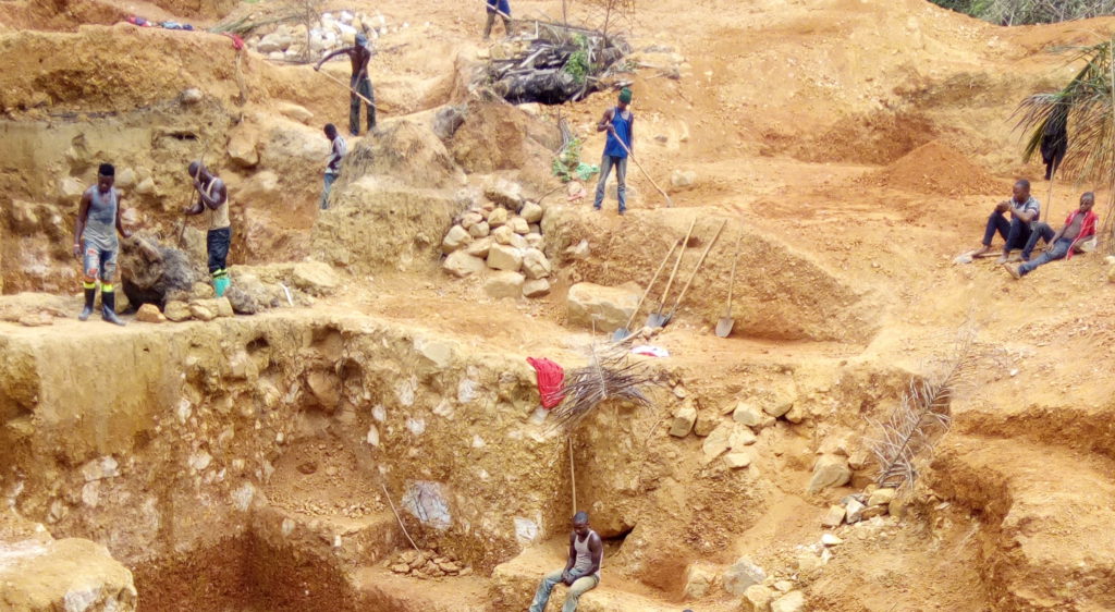
IPIS and the Zimbabwe Environmental Law Association (ZELA) collaborated to map artisanal and small-scale mining in the Runde Rural district of Zimbabwe. Following a training on Mobile Data Collection (MDC) tools organized by IPIS in November 2018, ZELA conducted a pilot study on Artisanal and Small-Scale Mining (ASM) in the area. Five groups of enumerators […]
Assessing the impact of due diligence programmes in Eastern DRC: A baseline study
Over the past decade, various legislative and due diligence programmes (DDP) have been developed to improve mining communities’ livelihoods and reduce human rights abuses in conflict affected and high- risk areas, with a special focus on the African Great Lakes region. Despite significant growth and investments in minerals certification and traceability schemes, data on the […]
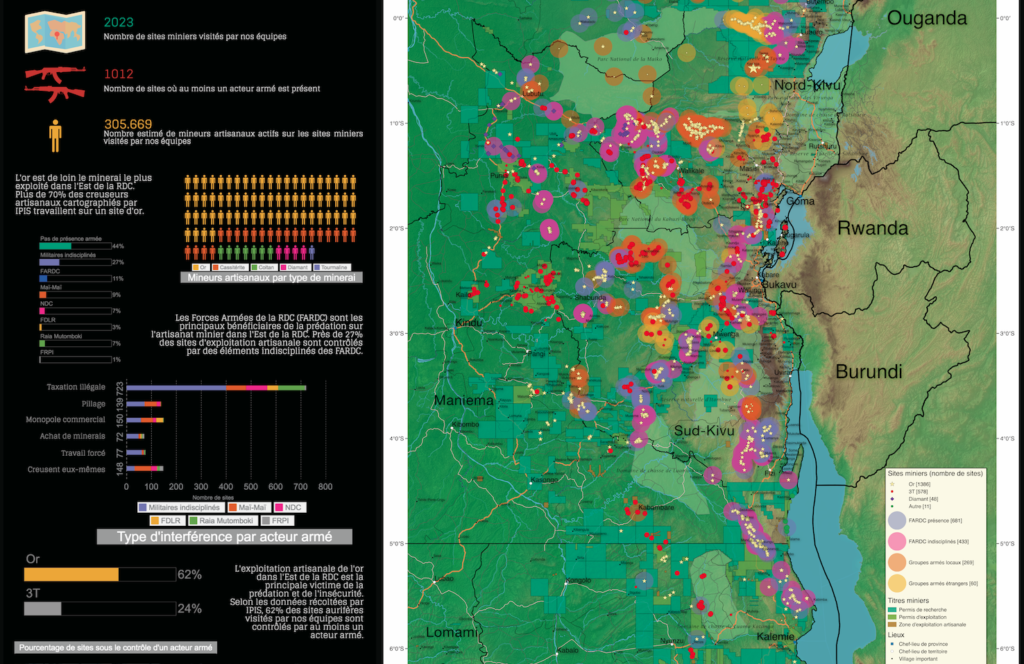
Mapping artisanal mining areas and mineral supply chains in eastern DRC (2019)

In a new report and webmap, IPIS presents its updated data on armed conflict and armed interference in eastern DRC’s artisanal mining sector. Building on extensive data, gathered over the last ten years, IPIS assesses the impact of responsible sourcing initiatives in DRC, designed to address armed interference in mineral supply chains. The report illustrates […]
ASM Incident Tracker

Welcome to Kufatilia, the ASM Incident Tracker developed by IPIS in collaboration with the Expertise Centre on Mining Governance (CEGEMI) based in Bukavu, and powered by Ulula. The ASM Incident Tracker is a tool for Congolese civil society organisations to report and monitor incidents in Eastern DRC in a transparent, independent and participatory way. The reported incidents, in […]
Infographic – The ATT, arms trade to Saudi-Arabia and violence in Yemen

The ongoing war in Yemen has transformed into a humanitarian catastrophe of unknown magnitude. Civilian casualties, estimated in the millions, continue to rise as do the number facing severe famine. Saudi Arabia and other parties to the Yemeni conflict stand accused of repeatedly violating international humanitarian law. In spite of these allegations, countries continue to […]
Mapping artisanal and small-scale mining in northwest Tanzania

IPIS has undertaken an unprecedented mobile data collection campaign, mapping 450 artisanal and small-scale mining and processing sites in northwest Tanzania. This serves to improve the evidence based on the sector, and contribute to a balanced understanding of its nature, scope and impact in Tanzania. Download the Report Visit the Interactive Webmap Download the full resolution static map […]
Capacity Building for a Responsible Minerals Trade
With the support of the Capacity Building for Responsible Minerals Trade, IPIS developed and implemented a methodology aimed at assessing the responsible sourcing potential of gold mining areas in South-Kivu. IPIS conducted field missions in seven gold trading hubs and their surrounding mines in South-Kivu: Shabunda centre (Shabunda territory), Katchungu (Shabunda territory), Mapimo (Shabunda territory), […]
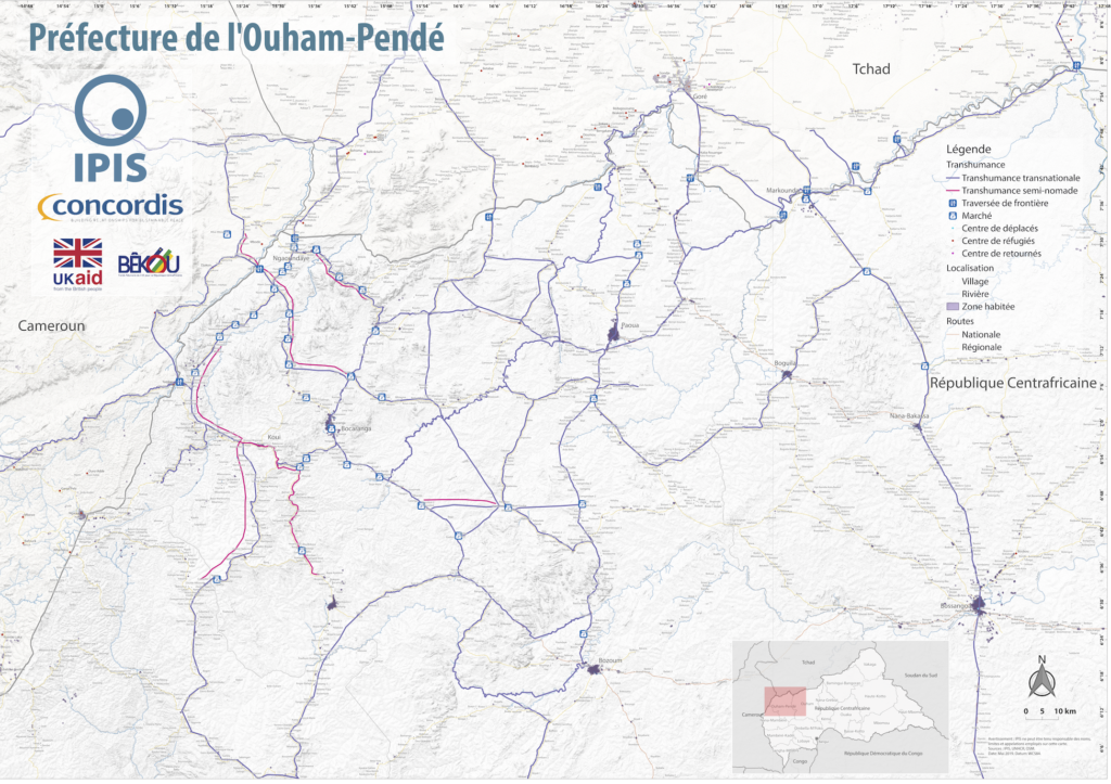
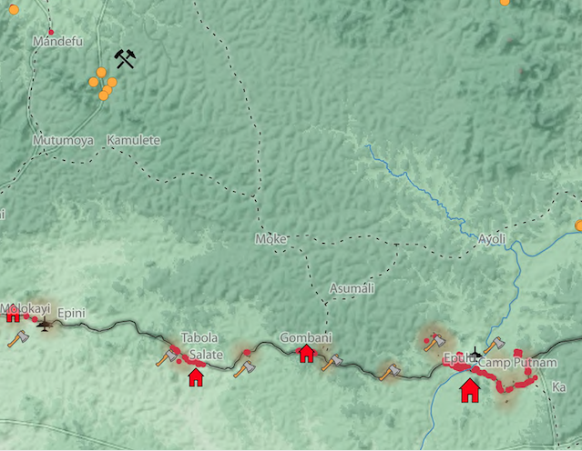
Central African Republic – Ouham-Pende Basemap (2019)

Each year the annual migration of transnational transhumance through the prefecture of Ouham-Pende, in northwestern Central African Republic (CAR), uproots a deep-seated mistrust between nomadic and sedentary communities. Escalating militancy and environmental pressures in the region has only amplified these issues in recent years. These maps, created by IPIS, detail the towns, villages, roads, IDP […]
Central African Republic: A Conflict Mapping (2018)
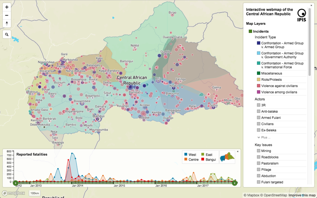
In a new report and webmap on the longstanding crisis in the Central African Republic (CAR), IPIS points out that access to resources remains the predominant driver of both armament and conflict in CAR. All armed groups operating in CAR are engaged in predation on one or more economic sectors. Such predation is not only […]
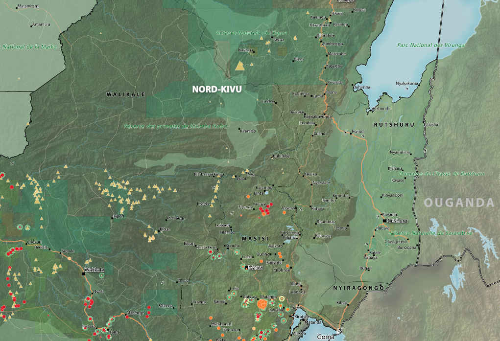
Roadblocks and artisanal mining sites – North and South Kivu Provinces (2018)
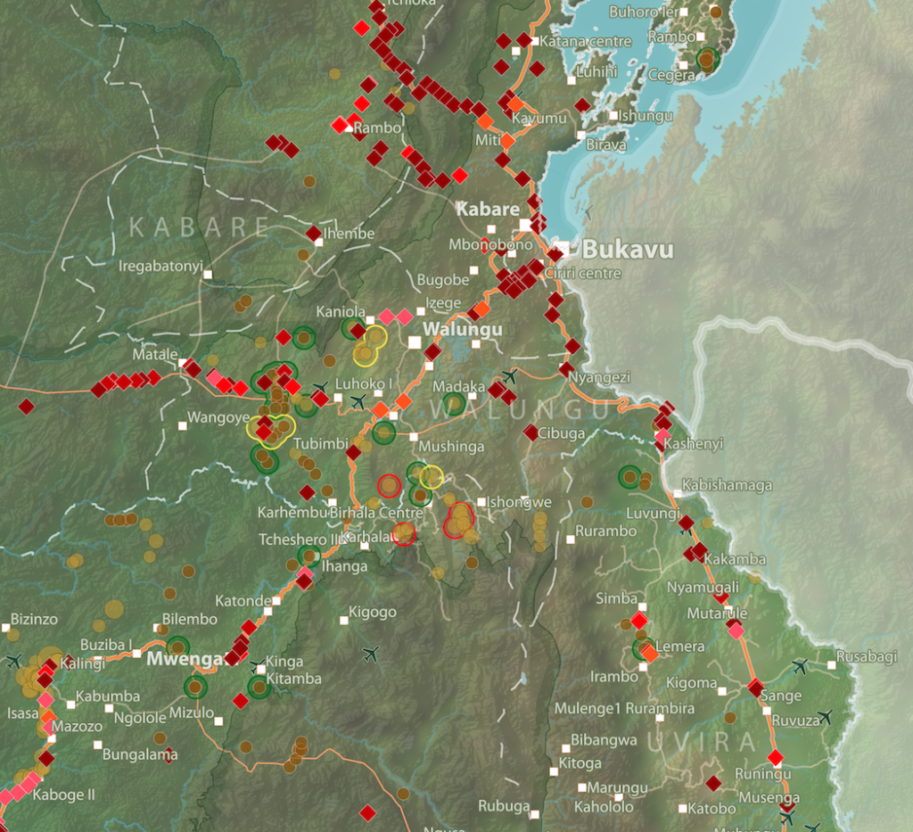
This map show the location of roadblocks and artisanal mining sites in the Kivu provinces. It was made by combining data from our recent report on roadblocks in the area, and data from our recent update of our database and webmap on artisanal mining sites in eastern DRC. Download the full image
Interactive map of artisanal mining exploitation in eastern DR Congo – 2018 update
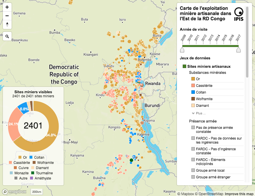
Résumé français ci-dessous – French summary below IPIS launched a major update of it’s DRC webmap displaying data on more than 2400 artisanal mining sites in eastern DRC and more than 800 roadblocks. Since December 2016, IPIS teams have visited more than 500 artisanal mines in eastern DRC, gathering data that has been added to […]
Okapi Wildlife Reserve: Illegal Sourcing of Gold and Timber (2018)
A map of the Okapi Wildlife Reserve in DRC, created as a result of two mapathons focussing on illegal activities in the park.
The Politics of Pillage: the political economy of roadblocks in the Central African Republic (2017)
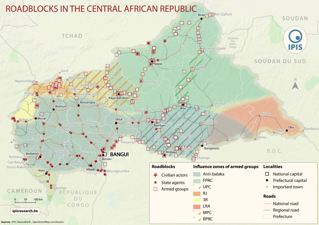
IPIS puts roadblocks on the map as key mechanism of conflict funding besides natural resources, revealing its devastating scope in funding armed actors in Democratic Republic of Congo and Central African Republic Mapping over a thousand roadblocks, IPIS uncovers the shocking extent of armed predation on trade routes in conflict-ridden Central Africa. Roadblocks, IPIS claims, […]
“Everything that moves will be taxed”: the political economy of roadblocks in North and South Kivu (2017)
IPIS puts roadblocks on the map as key mechanism of conflict funding besides natural resources, revealing its devastating scope in funding armed actors in Democratic Republic of Congo and Central African Republic Mapping over a thousand roadblocks, IPIS shows the shocking extent of armed predation on trade routes in conflict-ridden Central Africa. Roadblocks, IPIS claims, […]
Pastoralism corridors in Central African Republic (2017)
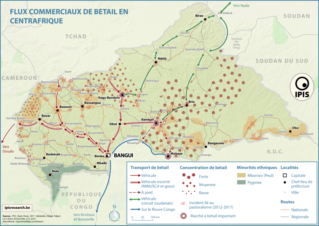
While pastoralism can generates wealth and economic interdependence between farmers and cattle herders, it can also causes tension and conflicts. In the current Central African Republic crisis context, transnational livestock migrations, particularly by Chadian and Sudanese herdsmen to CAR, have led to clashes between pastoralists and the local population. IPIS has developed a map showing […]
Artisanal Gold Monitoring Pilot (2017)
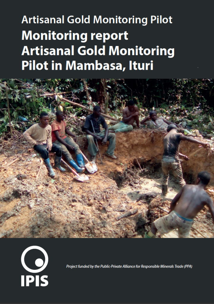
With the support of the Public Private Alliance for Responsible Minerals Trade (PPA), IPIS set up its Artisanal Gold Monitoring Pilot in Mambasa (Ituri Province, DRC) between April 2016 and July 2017. This involved developing a low-cost methodology to produce a continuous data flow on a wide range of indicators related to the operational, security […]
Conflict Minerals in Eastern DRC (2017)
Printing maps of conflict minerals in Eastern DRC.
Maps of Mining Sites in North Kivu (2017)
North Kivu Province – AO Map Lubero, Oicha, Butembo and Beni Territories – A0 Map Masisi Territory – A0 Map Masisi Territory, North Kivu Province, DRC Masisi Territory, North Kivu Province, DRC (Detail) Rutshuru Territory – A0 Map Rutshuru Territory, North Kivu Province, DRC Rutshuru Territory, North Kivu Province, DRC (Detail) […]