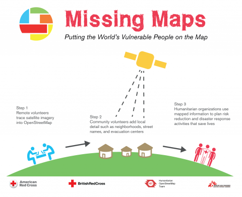
Missing Maps Mapathon / Wednesday, 26 October 2016
October 4, 2016IPIS, Missing Maps and OpenStreetMap Belgium organise another Missing Maps MAPATHON on Wednesday October 26, at the IPIS library! IPIS Research and Openstreetmap Belgium invite you to come map for the Missing Maps project with us. By doing so, you will learn how to create the open maps that make the work of NGOs like Doctors Without Borders or IPIS Research easier. After the ev
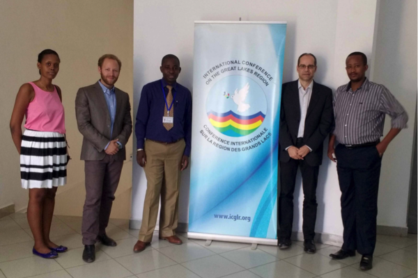
Design of the ICGLR regional database on mineral flows
September 6, 2016The Executive Secretariat of the International Conference on the Great Lakes Region (ICGLR), with the financial support of Partnership Africa Canada (PAC), has commissioned a consultancy to design the architecture of the ICGLR Regional Database on mineral flows, one of the six tools of the Regional Initiative on Natural Resources (Lusaka declaration). Estelle Levin Ltd. (ELL) and the International
Annual Report 2015
August 31, 2016Download pdf or open with issuu reader http://issuu.com/ipisresearch/docs/2016_10_10_ipis_jaarverslag_2015_20

Missing Maps mapathon / Wednesday, 29 June 2016
June 8, 2016IPIS, Missing Maps and OpenStreetMap Belgium organise another Missing Maps MAPATHON on Wednesday, June 29, at the IPIS library! IPIS Research and Openstreetmap Belgium invite you to come map for the Missing Maps project with us. By doing so, you will learn how to create the open maps that make the work of NGOs like Doctors Without Borders or IPIS Research easier. After the event, you wil
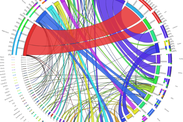
Accessible and Interactive: New Methods of Data Visualization as Tools for Data Analysis and Information Sharing in Transitional Justice Research
March 24, 2016Abstract The production and use of datasets is a growing area in transitional justice research. One constant limitation, however, is the way this data is visualized. Relying only on static graphics and tables, many of these datasets are insufficiently explored and analyzed, and remain inaccessible for other researchers. Interactive data visualization tools are an ideal method for overcoming this g
Missing Maps mapathon / Wednesday, 23 March 2016
February 17, 2016IPIS, Missing Maps and OpenStreetMap Belgium organise the mapping event ‘Missing Maps mapathon’ on Wednesday March 23 at the IPIS library! IPIS Research and Openstreetmap Belgium invite you to come map for the Missing Maps project with us. Doing so, you will learn how to create the open maps that make the work of NGOs like Doctors Without Borders or IPIS Research easier. After the event, you
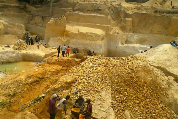
Mineral supply chains and conflict links in eastern democratic republic of congo
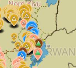
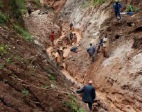
November 25, 2015Between 2009 and 2010 IPIS collected data on over 550 mining sites as part a conflict mapping exercise focusing on Eastern Democratic Republic of Congo (DRC). With the collaboration of Congolese researchers, IPIS collected the coordinates of the most important mining sites and information on on-site security in North and South Kivu provinces, Maniema, Northern Katanga and southeast Province Orient
COMING SOON! Missing Maps mapathon / Wednesday, 9 December 2015
November 12, 2015IPIS, Missing Maps and OpenStreetMap Belgium organise the mapping event ‘Missing Maps mapathon’ on Wednesday December 9th at the IPIS library! The Missing Maps project is an open collaboration between the Humanitarian OpenStreetMap Team (HOT), Doctors without Borders UK, and the British and American Red Cross. The goal of the project is to map the areas of the world that are the most sensitive to
Infographic – Mapping conflict motives in the CAR
January 28, 2015
Infographic – Mapping mining areas in eastern DRC
January 28, 2015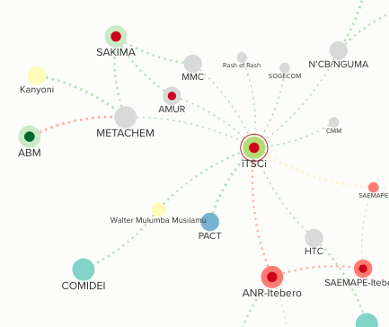
Stakeholder and power mapping tools
January 17, 2015IPIS has developed a methodology to map stakeholders and power structures. Following an in depth study through interview and literature review, this approach uses modern visualisation techniques to create interactive tools that map and visualize the power dynamics in conflict and post-conflict areas. These tools can be used to describe local, provincial, national, regional and international peace
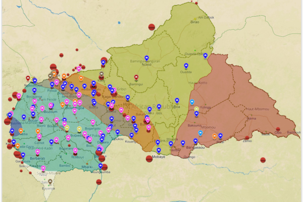
Mapping Conflict Motives: the Central African Republic (2012-2014)
November 21, 2014In this study, IPIS analyses the conflict dynamics in the Central African Republic (CAR) since the outbreak of the latest crisis in September 2012 up to September 2014. The analysis specifically looks into the motivations and interests of the main conflict parties, Seleka and anti-balaka, and the influence and interests of neighbouring countries. The report covers the following key questions. What
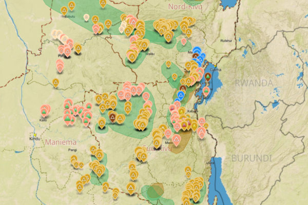
Analysis of the interactive map of artisanal mining areas in Eastern DRC – May 2014 Update
April 30, 2014In collaboration with the Congolese mining cadastre (CAMI), mining service SAESSCAM and representatives from local civil society organisations, IPIS organised a series of field visits to monitor artisanal mining activities and the involvement of armed groups and criminal networks in mineral exploitation and trade. This resulted in the publication of an interactive web map providing information on
Wereldbeeld: Nieuwste VN-vredesmissie start in de Centraal- Afrikaanse Republiek: Geweld, een zwakke veiligheidssector en de rol van de internationale gemeenschap. Lotte Hoex. pp 6-13
March 3, 2014Om burgers te beschermen tegen het aanhoudende geweld in de Centraal-Afrikaanse Republiek (CAR), ging op 15 september 2014 de nieuwste vredesmissie van de Verenigde Naties (VN) van start. De CAR ligt in centraal Afrika, telt vijf miljoen inwoners en is één van de armste landen ter wereld. Sinds de onafhankelijkheid van Frankrijk in 1960 kampt de CAR met een onstabiele politieke situatie en regelma
Mapping conflict motives: the Sudan – South Sudan border
January 29, 2014In this project, IPIS analyses the conflict dynamics in the wider border area spanning Sudan and South Sudan. The analysis specifically looks into the motivations and interests of the parties involved in the interstate, intrastate and local conflicts in this area.The examined period spans September 2012 – December 2013. The geographic areas covered include: the South Sudanese states of Western Bah
Mapping Conflict Motives: the Sudan – South Sudan border
January 23, 2014In “Mapping Conflict Motives: the Sudan-South Sudan border”, IPIS analyses the conflict dynamics in the wider border area spanning Sudan and South Sudan. The analysis specifically looks into the motivations and interests of the parties involved in the interstate, intrastate and local conflicts in this area. The report covers the following key questions: Where are conflict parties focussing their e
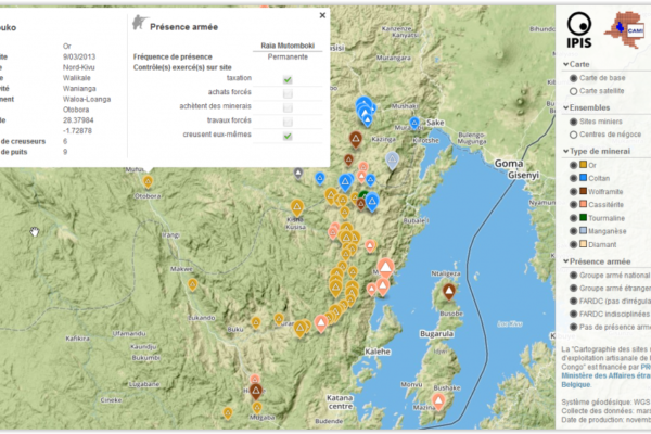
Analysis of the interactive map of artisanal mining areas in Eastern DR Congo (2013)
November 13, 2013In August 2009 the ‘International Peace Information Service’ (IPIS) published a first map of militarised mining areas in Eastern DR Congo. By 2012, the international interest in the issue had grown but the map was out-dated. To find a structural solution, IPIS sat down with the Congolese mining cadastre (CAMI) and agreed to set up a permanent system to monitor artisanal mining activities and the i
Mapping Conflict Minerals (2012)
December 28, 2012How GMES supports the International Peace Information Service (IPIS), in: Window on GMES, Special Issue: Discover the “S” in GMES, pp. 82-88 Exploitation of natural resources has, in most cases, a strong impact on the environment, often even spoiling natural habitats and affecting people’s way of life. The exploitation and trade of minerals can also fuel armed conflicts, as it is the case in the E
Mapping Conflict Motives: M23 (2012)
November 30, 2012In light of the recent occupation of Goma by M23 and the renewed risk of large-scale armed conflict in the DRC, IPIS publishes an update to its 2007-2010 ‘mapping conflict motives’ report series focussing specifically on the intentions of M23. The M23 rebels show a clear political ambition and a tendency to establish political control over territory and challenge Kinshasa’s authority – strategic i
A Taxonomy of Non-State Armed Actors in the Central African Republic (2012)
January 2, 2012This report hopes to provide an overview of how the Central African Republic got to where it is now, as well as to present the means to further our understanding of the current situation. First a genealogy of the current situation is provided, which is presented in the form of a narrative literature overview encompassing the postcolonial period. This is followed by a brief account on the main conf