During the second half of 2022, I had the chance to complete a GIS internship at IPIS in Antwerp. As a student pursuing a degree in both African Studies and Geography, I was eager to apply my existing knowledge from both fields and gather valuable insights and experience.
The main tasks of the GIS and data analysis team, and thus of my internship, included supporting other researchers in collecting, interpreting, and visualising data, assisting with the management of IPIS’s geographic databases, and creating statistics, visualisations, and maps. These tasks required a diverse set of technical skills, and I was able to learn and advance my skills in programming languages such as R and Python, SQL, the GIS software QGIS and the web application framework Shiny.
During the internship, I worked on various assignments including an A0 map for the embassy of a European country in Tanzania that had to be aesthetically appealing, and accurately present the complex information on different levels. Furthermore, I worked together with researchers at IPIS to find appropriate ways to visualise data and modify and extend existing design templates. As most of the data analysis workflows revolved around R and RStudio, I continuously kept myself up to date with new possibilities, changes, and extensions to the programming language and documented them. I also developed an R package for IPIS, which integrated self-programmed functions, example datasets, and executable examples with comprehensive documentation.
Additionally, I worked on modifying existing web-based applications and maps using the Shiny web framework. I integrated information pop-ups and interactive elements, whilst expanding my knowledge of HTML & CSS as well as concepts and technologies of web development.
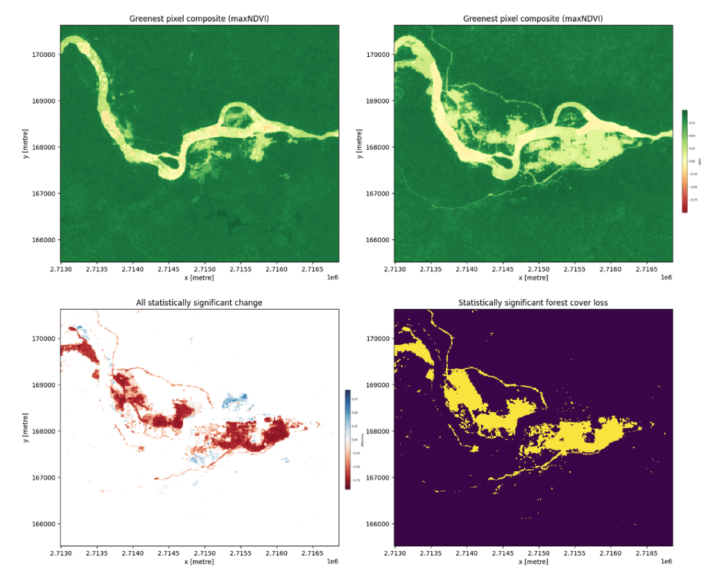
A significant portion of my internship involved analysing satellite imagery with Python to explore environmental changes at and around mining sites. I calculated vegetation indices, assessed forest cover changes, and monitored water expansion and changes in water quality parameters. The results were integrated into maps, graphs, time series, and video animations.
I also had the opportunity to work on my bachelor thesis project at IPIS, which aimed to explore the possibilities and challenges of using Remote Sensing to identify mining footprints in remote and densely vegetated locales such as found in eastern DRC. My supervisor Thomas Muller as well as other staff members gave me ample time and valuable input to work on this project.
My internship was a valuable experience that allowed me to explore the field of GIS and apply my knowledge and skills in a real-world setting and on compelling data. Working with the IPIS staff was a very collegial experience, and observing the expansion processes of the research institute was an interesting and stimulating process. The multidisciplinary nature of the institute’s work and staff mirrored what I had encountered in my studies and made me feel welcome and valued to quickly assume responsibility. Whilst doing so, Mr. Muller was supportive and challenged me without overwhelming me.
Overall, the job profile and day-to-day tasks largely met my expectations. I found the substantive work at the institute to be very interesting and engaging, and it has helped solidify my desire to stay in the GIS field as well as motivated me to further pursue educational opportunities in the field of peace and conflict research.
I would definitely recommend an internship at IPIS!
– Philip Knirsch

Interested in joining IPIS as a GIS intern? More information here