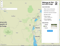
Since 2009, IPIS has collected geolocated data on artisanal and small-scale mining (ASM) sites in eastern DRC. The data collected in the field is publicly accessible on an interactive map. This webmap provides a range of information such as the type of mineral(s) produced, techniques and procedures of extraction – including the use of mercury -, number of workers, activities by women workers, child labour, presence and interference by state and non-state armed actors, roadblocks, presence of state services, traceability programmes, mineral sales points and destination, and the legal status of the mine. Data collection methods and verification rely extensively on triangulation of sources, and interviewees include artisanal miners, shop keepers, representatives of cooperatives and heads of miner camps. Most sites have been visited multiple times since 2009 and as of June 2023, IPIS teams have proceeded to a total of 6,955 visits.
The data collection campaigns have enabled IPIS to generate a sizable database of more than 3,400 ASM sites that draws both on sites visited by IPIS and data from third party sources including the Congolese mining cadastre and the Ministerial qualification teams.

Discover the webmap’s features
Examine ASM sites and roadblocks
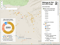
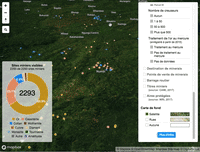
The webmap shows primarily the location of ASM sites visited by IPIS and third-party sources. Click on mines to learn more about the kind of minerals produced, the presence of (state and non-state) armed actors – possibly engaging in specific illegal activities – or state services operating at the site. Pictures are available for the majority of the mines and can be navigated using a slider. Additionally, a compact pop-up feature enables further exploration of mineral sales locations and checkpoints.
Filter your selection
Use the filter on the right end of the map to focus your research on specific types of mines or roadblocks. Mines can be filtered on general properties such as the minerals mined, the year it has been visited, or the presence of armed actors. More specific properties can also be used to filter according to the use of mercury for gold processing, or the ministerial validation status of the mine. Roadblocks can be filtered on the operator at the roadblock, or on the type of roadblock.
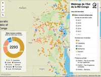
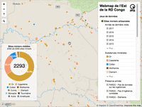
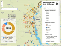
Count all filtered mines
A small graph in the lower left of the map shows the total number of mines that are selected by the current filters, and tells you how these are distributed over the various minerals. Use it in combination with the filters to investigate how prevalent certain mining site characteristics are.
See the influence zones of armed groups.
The webmap includes a feature labeled ‘Zones d’ingérence’ which casts a shaded overlay around mining sites that have experienced unlawful interventions, as noted in the most recent reports. The shading varies in color to correspond with the specific armed group identified at each location, delineating their potential territorial sway.
Search for specific features
A useful search function in the top left of the map allows you to search for specific mines, selling points, locations and more. A smooth zooming transition brings you straight to where you need to be!
Discover the local trade flows
During its visits to mining sites, IPIS documents the locations where minerals are sold and tracks the ultimate destinations of the minerals sourced from each site within the eastern DRC. illustrating the connections from mining sites to their corresponding sales points and onward to the final destinations effectively clarifies the trade patterns within the region. The use of different colours per actor allows you to reveal the interference of armed actors at the mining site where minerals are produced.
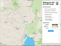
Learn about the context
Additional web layers such as mining concessions (‘Titres miniers’) and protected areas (‘Aires protégées’) help understanding the context in which the mining sites activities and roadblocks take place. It is also possible to choose between different satellite or street view basemap layers made available by Mapbox and Bing.
A snappier webmap experience
IPIS build its webmaps with the latest webmapping technology. This version uses Mapbox GL to render the map live in your browser. If you like this webmap and would like a similar one for you own project, contact us!
Explore further
For those interested in a more detailed examination of the data underpinning the webmap, the opportunity is available. Select layers featured on the webmap can be accessed via the Open Data page and the IPIS Open Data dashboard. The dashboard was designed to complement the webmap providing key visuals to enhance understanding of the ASM sector in eastern DRC.
