Mapping artisanal mining areas and mineral supply chains in eastern DRC (2019)

In a new report and webmap, IPIS presents its updated data on armed conflict and armed interference in eastern DRC’s artisanal mining sector. Building on extensive data, gathered over the last ten years, IPIS assesses the impact of responsible sourcing initiatives in DRC, designed to address armed interference in mineral supply chains. The report illustrates […]
ASM Incident Tracker

Welcome to Kufatilia, the ASM Incident Tracker developed by IPIS in collaboration with the Expertise Centre on Mining Governance (CEGEMI) based in Bukavu, and powered by Ulula. The ASM Incident Tracker is a tool for Congolese civil society organisations to report and monitor incidents in Eastern DRC in a transparent, independent and participatory way. The reported incidents, in […]
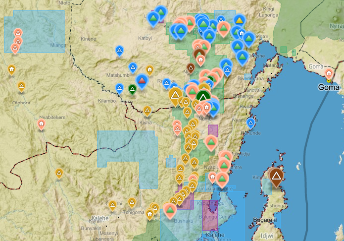
Roadblocks and artisanal mining sites – North and South Kivu Provinces (2018)
This map show the location of roadblocks and artisanal mining sites in the Kivu provinces. It was made by combining data from our recent report on roadblocks in the area, and data from our recent update of our database and webmap on artisanal mining sites in eastern DRC. Download the full image
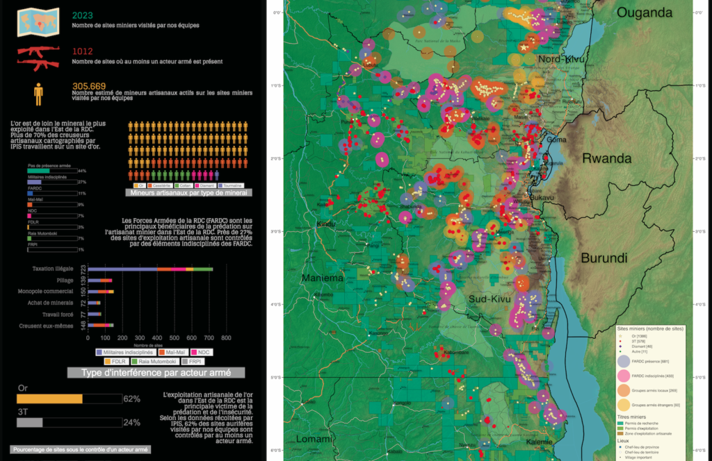
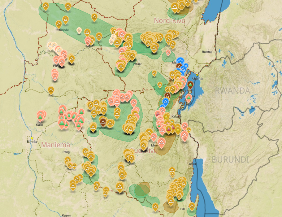
Interactive map of artisanal mining exploitation in eastern DR Congo – 2018 update
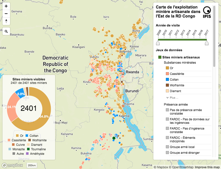
Résumé français ci-dessous – French summary below IPIS launched a major update of it’s DRC webmap displaying data on more than 2400 artisanal mining sites in eastern DRC and more than 800 roadblocks. Since December 2016, IPIS teams have visited more than 500 artisanal mines in eastern DRC, gathering data that has been added to […]
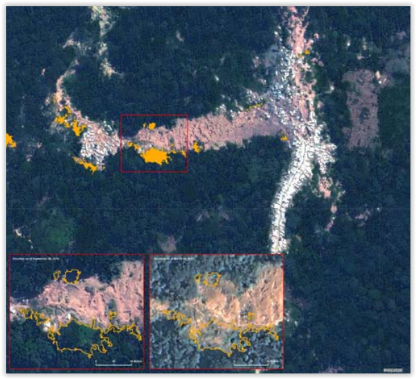
Okapi Wildlife Reserve: Illegal Sourcing of Gold and Timber (2018)
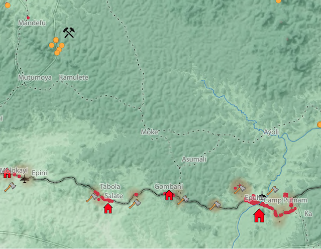
A map of the Okapi Wildlife Reserve in DRC, created as a result of two mapathons focussing on illegal activities in the park.
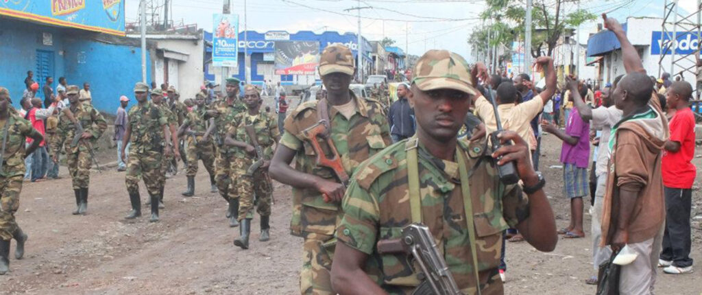
“Everything that moves will be taxed”: the political economy of roadblocks in North and South Kivu (2017)
IPIS puts roadblocks on the map as key mechanism of conflict funding besides natural resources, revealing its devastating scope in funding armed actors in Democratic Republic of Congo and Central African Republic Mapping over a thousand roadblocks, IPIS shows the shocking extent of armed predation on trade routes in conflict-ridden Central Africa. Roadblocks, IPIS claims, […]
Artisanal Gold Monitoring Pilot (2017)
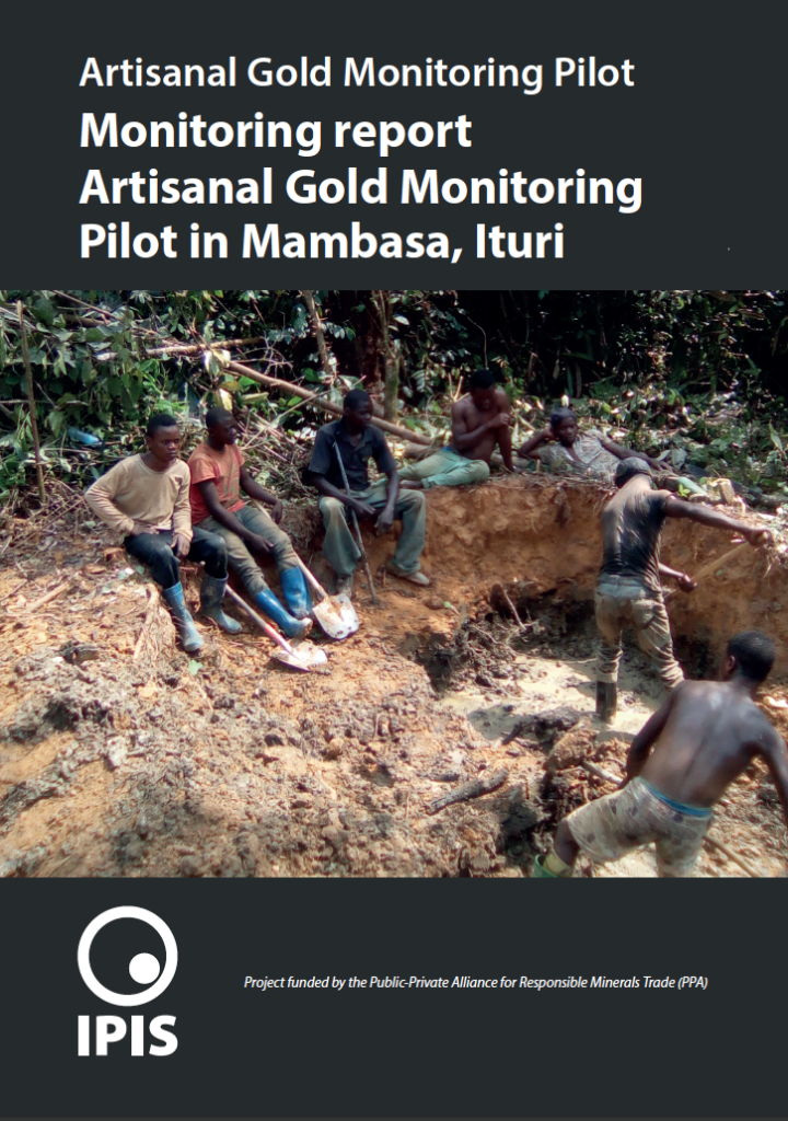
With the support of the Public Private Alliance for Responsible Minerals Trade (PPA), IPIS set up its Artisanal Gold Monitoring Pilot in Mambasa (Ituri Province, DRC) between April 2016 and July 2017. This involved developing a low-cost methodology to produce a continuous data flow on a wide range of indicators related to the operational, security […]
Conflict Minerals in Eastern DRC (2017)
Printing maps of conflict minerals in Eastern DRC.
Maps of Mining Sites in North Kivu (2017)
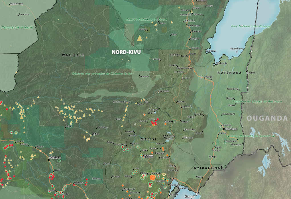
North Kivu Province – AO Map Lubero, Oicha, Butembo and Beni Territories – A0 Map Masisi Territory – A0 Map Masisi Territory, North Kivu Province, DRC Masisi Territory, North Kivu Province, DRC (Detail) Rutshuru Territory – A0 Map Rutshuru Territory, North Kivu Province, DRC Rutshuru Territory, North Kivu Province, DRC (Detail) […]
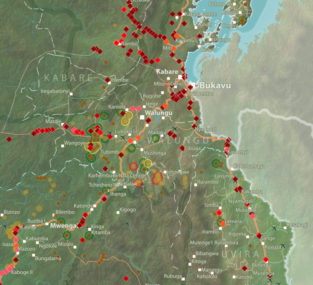
Maps of mining sites in South Kivu (2017)
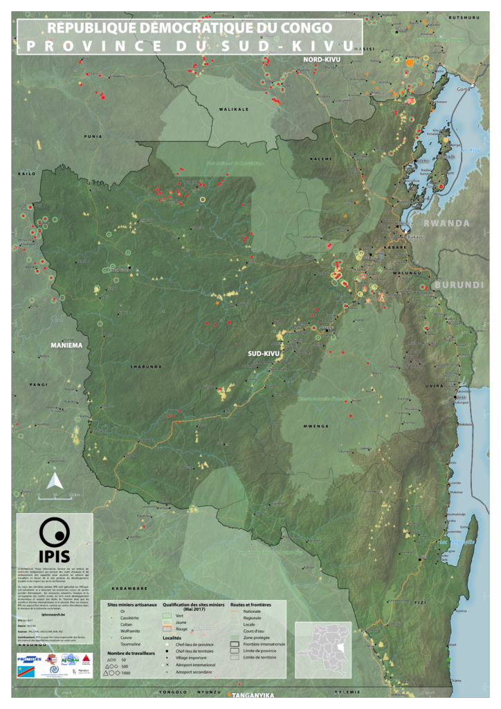
South Kivu Province – A0 Map Walungu Territory – A0 Map Idjwi Territory – A0 Map Kabare Territory, South Kivu – A0 Map Kalehe Territory – A0 Map Mwenga Territory – A0 Map Shabunda Territory – A0 Map Uvira Territory – A0 Map
Maps of Mining Sites in Ituri (2017)
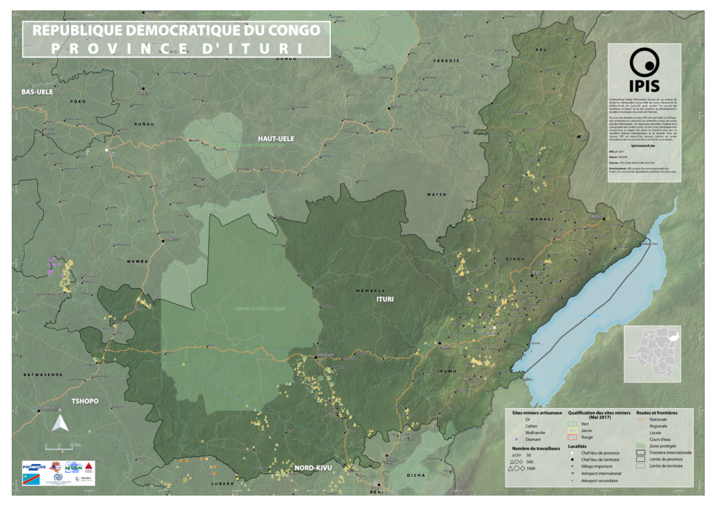
Map of Ituri Province of Ituri, DRC (Detail) Map of Mambasa Territory Territory of Mambasa, Province of Ituri, DRC (Detail)
Comprendre la spirale de la violence au Kasaï (2017)
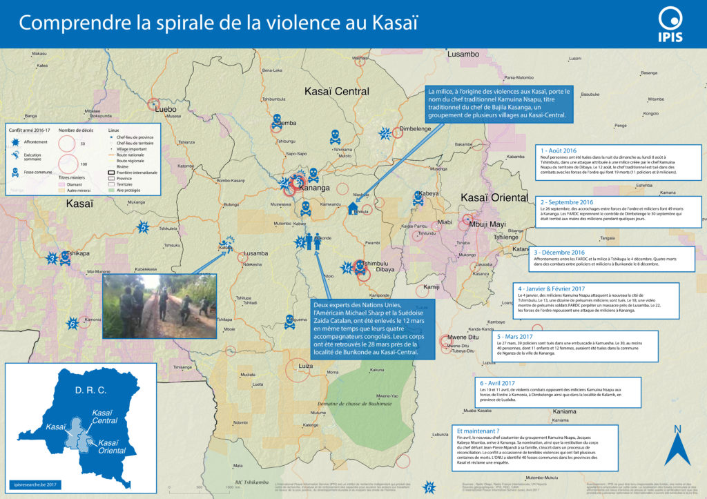
Le Kasaï Central et trois autres provinces voisines sont en proie à des violences mêlant miliciens, policiers et soldats et ayant fait, selon un rapport récent des Nations Unies, plus de 200 morts. Depuis septembre, un soulèvement des partisans du chef coutumier Kamwina Nsapu, tué en août par les forces de l’ordre après s’être rebellé […]
Pillage route: l’économie politique des barrages routiers à Walikale et Masisi (2017)
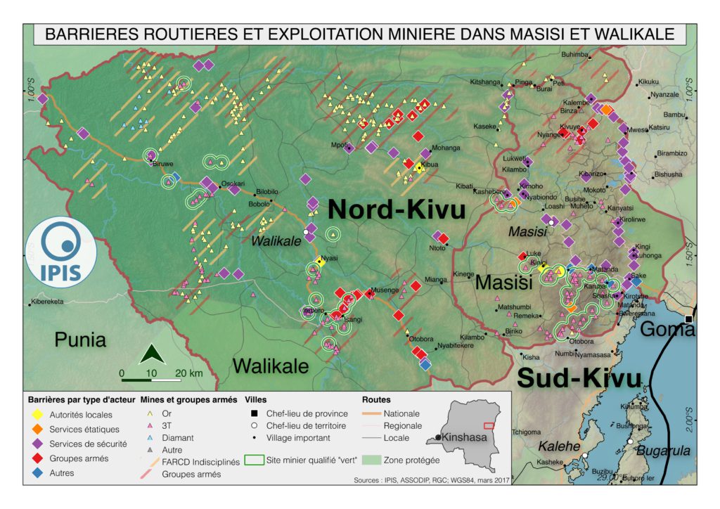
French version below – version française ci-dessous Roadblocks are a ubiquitous phenomenon in Eastern Congo. In an effort to map the scope of this phenomenon as well as its significance in the political economy of conflict, IPIS has embarked on a collaboration with the Danish Institute for International Studies. The point of departure is […]
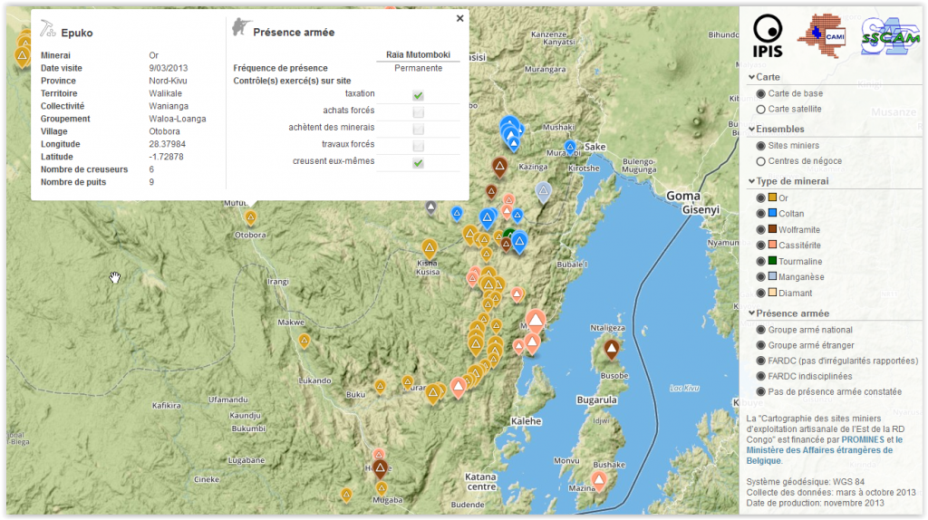
Analysis of the interactive map of artisanal mining areas in eastern DR Congo – 2015 update
The Belgian research group IPIS has collected data on 2026 artisanal mining sites in eastern DRC over the last couple of years. IPIS observed an armed presence in more than half of the mines. In an interactive map, updated in 2015, IPIS provides information about the on-site presence of armed groups and the Congolese army […]
Maniema province – A0 map (2015)
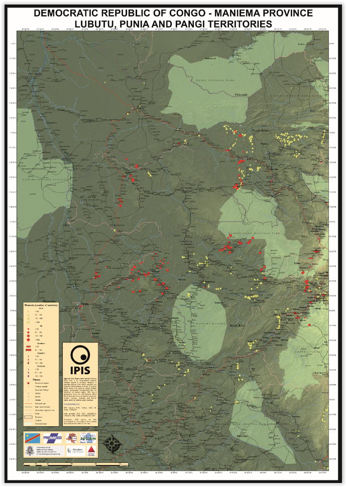
This is an A0 map of the Lubutu, Punia and Pangi Territories in Maniema Province, DRC
Analysis of the interactive map of artisanal mining areas in Eastern DRC – May 2014 Update
In collaboration with the Congolese mining cadastre (CAMI), mining service SAESSCAM and representatives from local civil society organisations, IPIS organised a series of field visits to monitor artisanal mining activities and the involvement of armed groups and criminal networks in mineral exploitation and trade. This resulted in the publication of an interactive web map providing […]
Analysis of the interactive map of artisanal mining areas in Eastern DR Congo (2013)
In August 2009 the ‘International Peace Information Service’ (IPIS) published a first map of militarised mining areas in Eastern DR Congo. By 2012, the international interest in the issue had grown but the map was out-dated. To find a structural solution, IPIS sat down with the Congolese mining cadastre (CAMI) and agreed to set up […]
Mapping Conflict Minerals (2012)
How GMES supports the International Peace Information Service (IPIS), in: Window on GMES, Special Issue: Discover the “S” in GMES, pp. 82-88 Exploitation of natural resources has, in most cases, a strong impact on the environment, often even spoiling natural habitats and affecting people’s way of life. The exploitation and trade of minerals can also […]
Mapping Conflict Motives: M23 (2012)
In light of the recent occupation of Goma by M23 and the renewed risk of large-scale armed conflict in the DRC, IPIS publishes an update to its 2007-2010 ‘mapping conflict motives’ report series focussing specifically on the intentions of M23. The M23 rebels show a clear political ambition and a tendency to establish political control […]
Bisie. A one-year snapshot of the DRC’s principal cassiterite mine (2011)
Much has happened in the mining sector of Eastern DRC over the last year. President Kabila imposed a ban on all mining activities last fall, during which production fell considerably. As soon as the suspension was lifted in the spring of this year, the major global electronic companies stopped buying minerals from the region, provoking […]