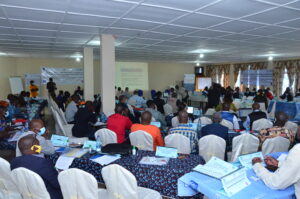
Workshops to present the results of the mapping of artisanal mining sites carried out in Ituri
Following this research, the results were presented in workshops in the above-mentioned territories to mining monitoring committees and project stakeholders in August 2025, facilitated by the IPIS focal point, Justice Plus staff and the IPIS research team. The aim of these feedback sessions was to share the results of our research with local actors in order to make them more accessible, enable them to contribute to the exchanges and discussions, enrich them if necessary, and take ownership of and validate the results of the reports.
“The Blue Mine” as a new status for qualifying mine sites in DRC. The result of successful advocacy by the Madini Project
On November 12th 2021, the National Minister of Mines of the Democratic Republic of Congo (DRC), Madam Antoinette N’Samba Kalambayi, signed the ministerial decree instituting
IPIS welcomes University of Antwerp Summer School for workshop on artisanal diamond mining
On August 28th, 2019, 21 students from the University of Antwerp’s ‘Mine to Finger’ Summer School on diamonds were engaged on “The use of digital

Working on conflict mapping through GIS – A goodbye from our latest GIS intern
I arrived at IPIS in January of this year with the purpose to further improve my GIS skills and work on the topic of conflict
Pastoralism in the Central African Republic conflict: new IPIS research launched
With thorough conflict mapping and analysis of the drivers and actors of conflict in the Central African Republic, IPIS has contributed to a better understanding
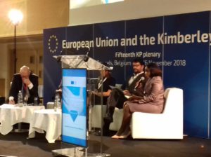
Kimberley Process Civil Society Coalition calls on all Members to deliver on improving global diamond governance
Reform is high on the agenda of this year’s Kimberley Process Plenary under EU Chairmanship. The Kimberley Process – once a pioneering tripartite effort to

22 November – IPIS panel discussion on the Central African Republic
Central African Republic: A Conflict Mapping IPIS kindly invites you to a panel discussion on the conflict in the Central African Republic on Thursday November
IPIS welcomes UA Summer School students for workshop on responsible sourcing using IPIS maps
On September 6th, 30 students from the University of Antwerp ‘Mine to Finger’ Summer School on diamonds participated in a responsible sourcing workshop organised by
Training and workshop on mapping artisanal mining in Eastern DRC
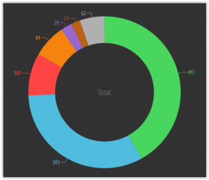
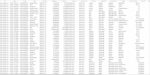
(French version below) 2373 Mining sites visited, including 470 visits in the last thirteen months. 300 Roadblocks visited on a total of 798 mapped roadblocks.
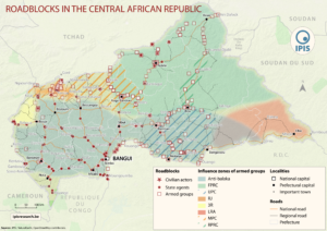
Roadblock rebels: IPIS maps important mechanism of conflict funding in Central Africa
IPIS puts roadblocks on the map as key mechanism of conflict funding besides natural resources, revealing its devastating scope in funding armed actors in Democratic

New Mapathon with special focus on DRC National Parks at IPIS
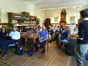
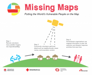
IPIS, Missing Maps and OpenStreetMap Belgium organise another Missing Maps Mapathon on Wednesday December 6, in the IPIS library. Why do we organise this? NGOs working
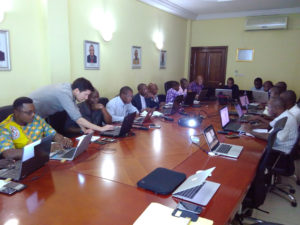
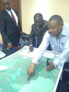
Capacity enhancement workshop on cartography with DRC mining authorities
Capacity enhancement workshop on cartography with DRC mining authorities In the framework of its long standing partnership with DRC mining authorities, IPIS held a workshop
IPIS opens up its data!
Data collection on peace, development and human rights is an essential part of the research work we do at IPIS. Because we believe in the
IPIS hosts new Missing Maps Mapathon with special focus on DRC National Parks
IPIS, Missing Maps and OpenStreetMap Belgium organise another Missing Maps Mapathon on Wednesday April 26, in the IPIS library. Why do we organise this? NGOs working in

Presentation of Gephi, an open source network visualisation tool
During the GeONG 2016 conference organised by CartONG in Chambery from 17th to 19th October, IPIS researcher AlexandreJaillon animated a workshop on Gephi, an open-source

Missing Maps Mapathon / Wednesday, 26 October 2016
IPIS, Missing Maps and OpenStreetMap Belgium organise another Missing Maps MAPATHON on Wednesday October 26, at the IPIS library! IPIS Research and Openstreetmap Belgium invite you to
Design of the ICGLR regional database on mineral flows
The Executive Secretariat of the International Conference on the Great Lakes Region (ICGLR), with the financial support of Partnership Africa Canada (PAC), has commissioned a
Missing Maps mapathon / Wednesday, 29 June 2016
IPIS, Missing Maps and OpenStreetMap Belgium organise another Missing Maps MAPATHON on Wednesday, June 29, at the IPIS library! IPIS Research and Openstreetmap Belgium invite you to
Missing Maps mapathon / Wednesday, 23 March 2016
IPIS, Missing Maps and OpenStreetMap Belgium organise the mapping event ‘Missing Maps mapathon’ on Wednesday March 23 at the IPIS library! IPIS Research and Openstreetmap Belgium
COMING SOON! Missing Maps mapathon / Wednesday, 9 December 2015
IPIS, Missing Maps and OpenStreetMap Belgium organise the mapping event ‘Missing Maps mapathon’ on Wednesday December 9th at the IPIS library! The Missing Maps project