Welcome to the IPIS Open Data page. IPIS publishes a growing number of datasets as Open Data. Here, you can find out how to access and use them.
About our Open Data
The International Peace Information Service (IPIS) publishes a selection of its datasets as Open Data. These datasets originate from our data collection campaigns and research, and have been internally reviewed and processed. The Open Data is linked to our internal database, such that a download includes the most up to date data-points and reflect the current status of the data as accessible through the IPIS webmaps on the same topics. We are committed to publish Open Data that is reliable, tidy and recent, as we believe that this is can be an essential factor for a good research climate. When collecting data on a new topic, we may however choose to maintain a delay period (up to 6 months) between the publication of a report and the disclosure of the information as Open Data.
Here are some tools you can use to start working with our data:
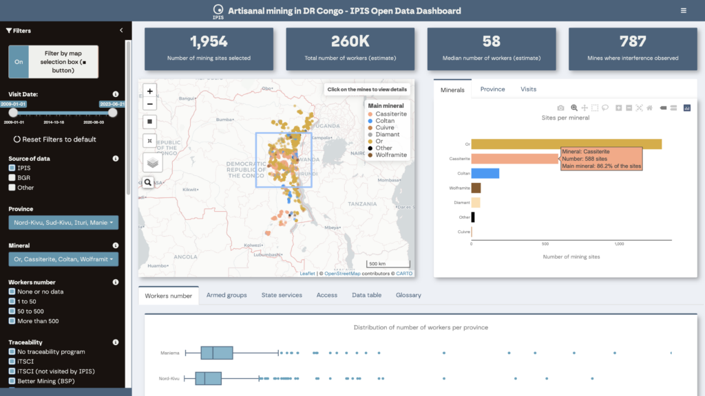
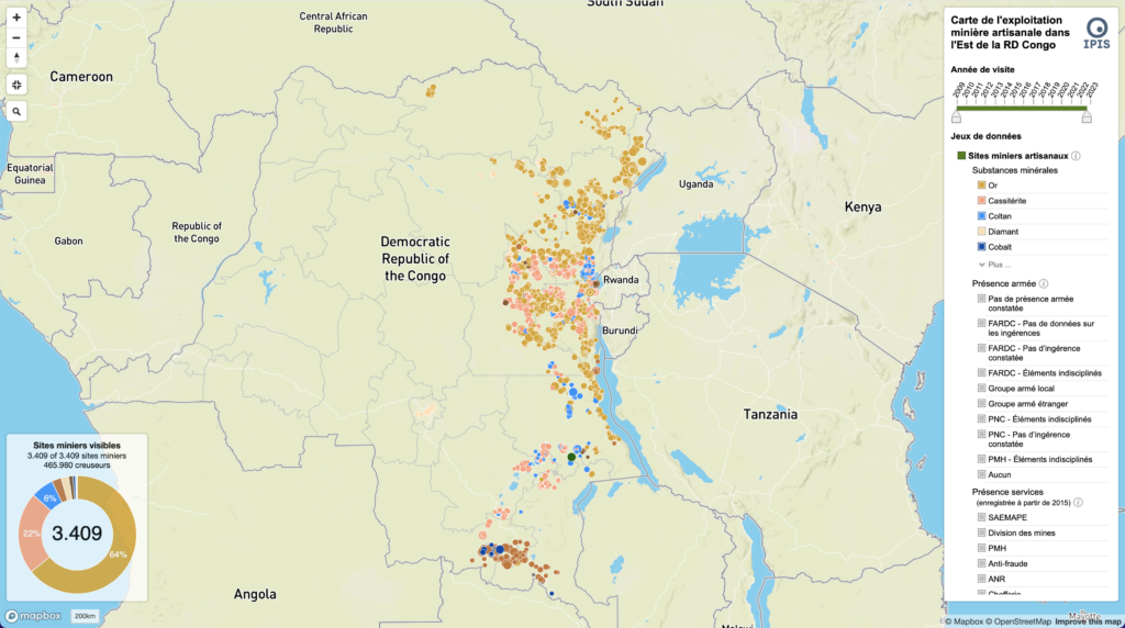
- The IPIS Open Data dashboard on artisanal and small-scale mining (ASM) in the eastern Democratic Republic of the Congo (DRC) enables users to query and subset IPIS Open Data using various combinations of filters.
- The Open Data FAQ & Dictionary page helps you understand the different columns and values present in our data.
- The Open Data ‘Getting Started using Excel’ explains how to use our data in Microsoft Excel and briefly introduces some properties of the data.
- The Open Data Tutorial was created for more advanced data researchers and gives a more thorough introduction to the data and the possible statistics which can be computed from it.
If you still have questions, don’t hesitate to contact us!
Accessing our Open Data
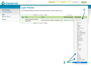
The datasets we publish can be accessed on the web via the dedicated download page, which lists the datasets available for download. Use the drop down menus to start downloading a layer is a specific format. We advise downloading as CSV or GeoJson. Downloading as Shapefile is possible as well, but will lead to abbreviated column names and errors with exotic characters (‘é’, …). Want to use Excel? Then download as CSV and use our Getting Started page!
Some notes on downloading our data:
- Downloading using the Safari browser might not work. Use Firefox or Chrome instead.
- Tabular layers (which have no geographic columns and can be identified by their name through “…_t_…”) can not be downloaded as Shapefiles or in other geographic formats, but can be downloaded as .csv or .json.
- Since we use standard OGC services to publish our data, these datasets can also be directly added to a GIS software project or webmap. To achieve this, one can use the following links to our WMS and WFS services:
No username/password is required. We’ve also enabled CORS and JSONP on our GeoServer to enable you to use WFS and WMS calls directly in your scripts, without the need to set up a proxy!
Open Data License
The data we publish is available under the ‘Open Data Commons Attribution License (ODC-BY) v1.0’ license, which basically requires a correct attribution to IPIS every time you use our data – see the full license and the human-readable summary.
Need help?
Don’t hesitate to contact us if you have questions on the data we share, or if you are keen to explore how we can help one another on data collection experience in the field.
We look forward to see where our data can help! Send us feedback about our Open Data content or service, and drop us a line to share what you made with it!
Other Open Source initiatives at IPIS
For some of our webmaps, we’ve published much of underlying code to our GitHub. Our intent is to inspire and help other people and organisations with similar projects. By making the code accessible, we stimulate reuse and help create and open community. Feel free to take a look! Also, we organise Mapathons from time to time to contribute to OpenStreetMap.