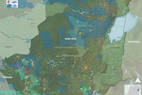
The M23 “version 2” – Local stakes, motivations, perceptions, and impacts
April 4, 2024Since 2021, the eastern part of the Democratic Republic of Congo (DRC) has once again fallen victim to the “March 23 Movement” (M23). Supposedly defeated in 2013, the M23 took up arms again in 2021, and by 2022 had rapidly seized vast territories in the south-east of North Kivu province.
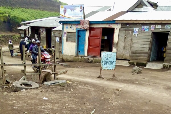
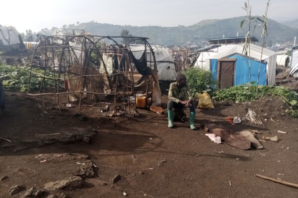
Roadblocks in Masisi and Walikale: Predation on movement in turbulent times
March 8, 2024While minerals have centered in research on conflict financing in the Democratic Republic of the Congo, armed actors often rely on alternative sources of revenue to finance their struggles. Among these are the operation of roadblocks. In this report, produced together with ASSODIP and the Danish Institute for International Studies, IPIS studies the linkage between roadblocks and the local artisana
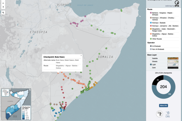
Mapping the political economy of checkpoints in Somalia
December 20, 2023The maps inform users on the locations of roadblocks across Somalia, the distribution of violence at checkpoints as well as the density of checkpoints per administrative region. Different maps also identify varying characteristics of the roadblocks, including their operator, location on a primary/secondary road and the amount paid at the checkpoint as toll.
Checkpoint economy: the political economy of checkpoints in South Sudan, ten years after independence
December 10, 2021Ten years after independence, the world’s youngest country is home to an entrenched political economy of conflict premised on checkpoint taxation. Humanitarian aid is not exempt, reveals a major new mapping report by DIIS and IPIS. When South Sudan became independent ten years ago, oil revenues were supposed to fuel the economy of the world’s newest country. But two years later in 2013, oil prices
Advocating for an improved enabling environment for the production, trade and export of OECD Due Diligence Guidance (DDG)-conformant minerals from eastern DRC
November 23, 2021As part of the Madini project, a review of the current situation, trends and barriers in the production, trade and export of tin, tantalum, tungsten (3T) and gold from eastern Democratic Republic of Congo (DRC) was conducted by Levin Sources, with the aim to recommend concrete actions that can improve OECD-conformant sourcing of these minerals from eastern DRC. The link between the exploitation of
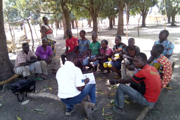
Promoting peaceful and seasonal migration in Northern Central African Republic
February 9, 2021“You can negotiate with an armed group, not with the drought” The borderlands of the Central African Republic (CAR) are home to one of the largest seasonal livestock migrations (transhumance) in the world. Decades of unrest and crisis, however, have brutally disrupted most aspects of herding—the routes taken, the people involved, governance mechanisms, as well as relations to local populations. To
Annual Report 2019
August 26, 2020This 2019 annual report provides an overview of IPIS’ research projects, capacity enhancement and outreach activities throughout last year. Read the full activity report to see what IPIS has been up to in 2019.
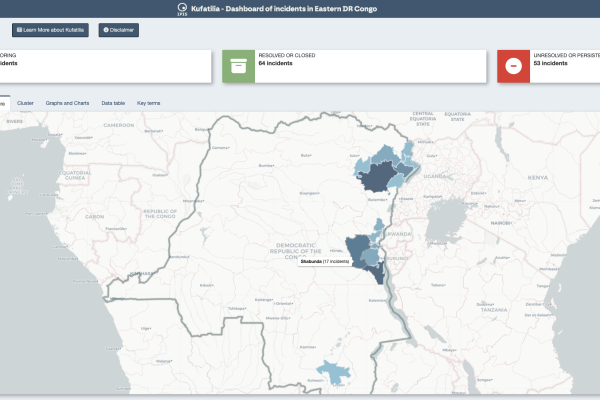
Dashboard of incidents in eastern DRC – Kufatilia
June 10, 2020The Kufatilia platform (“to track” in Swahili) is an SMS based incident reporting and follow-up mechanism that has been launched in 2019 to increase transparency of minerals supply chains in Eastern DRC. Developed by IPIS in partnership with the Centre for Expertise on Mining Governance (CEGEMI) based in Bukavu, and powered by Ulula, Kufatilia is a tool for Congolese civil society organisations to
Maps of conflict minerals in Eastern DRC (2020)
June 9, 2020IPIS created maps of conflict minerals in eastern DRC, more particularly on Haut Uele, Ituri and North and South Kivu. These maps detail the type of minerals, the qualification of the mines, the mining titles and give an overview of armed presence in and around the mines. d Download the North Kivu map in full resolution Download the South Kivu map in full resolution Download the Haut
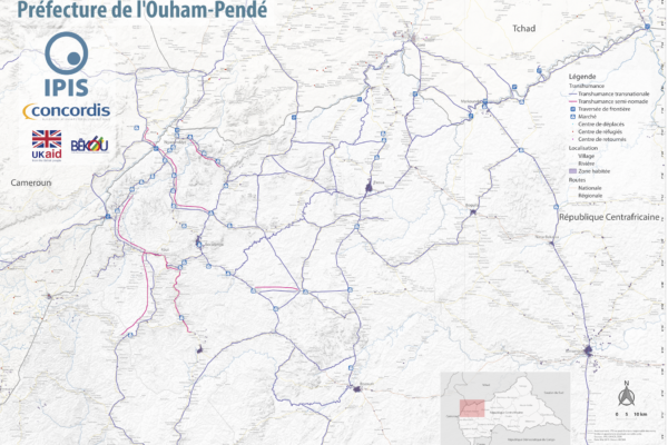
Map Pastoralism Ouham Pendé (2019)
September 12, 2019Each year the annual migration of transnational transhumance through the prefecture of Ouham-Pende, in northwestern Central African Republic (CAR), uproots a deep-seated mistrust between nomadic and sedentary communities. Escalating militancy and environmental pressures in the region has only amplified these issues in recent years.In partnership with Concordis International, IPIS hopes to enhance
Annual Report 2018
June 27, 2019This 2018 annual report provides an overview of IPIS’ research projects, capacity enhancement and outreach activities throughout last year. IPIS consolidated its work in DRC, Central African Republic and Tanzania and deepened its expertise on mapping, data analysis and research on conflict drivers, natural resources, Business & Human Rights and arms trade. IPIS worked closely with civil societ

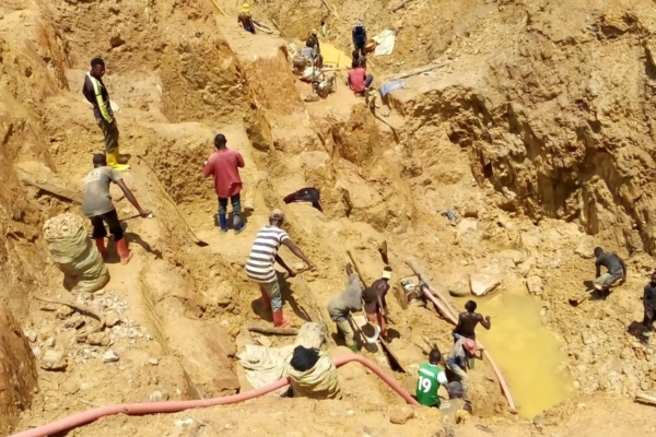
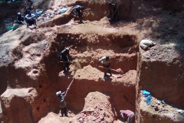
Mapping artisanal mining areas and mineral supply chains in eastern DRC (2019)
April 9, 2019In a new report and webmap, IPIS presents its updated data on armed conflict and armed interference in eastern DRC’s artisanal mining sector. Building on extensive data, gathered over the last ten years, IPIS assesses the impact of responsible sourcing initiatives in DRC, designed to address armed interference in mineral supply chains. The report illustrates that responsible sourcing efforts have
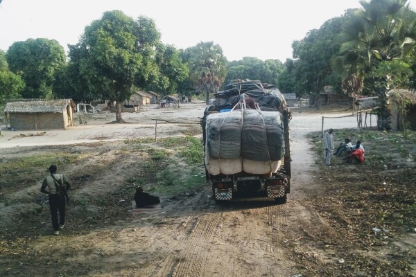
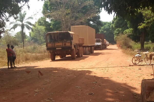
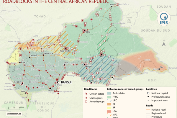
Article – The Political Economy of Roadblocks in the Central African Republic
October 2, 2018From September 2016 to September 2017, the International Peace Information Service (IPIS) and the Danish Institute for International Studies (DIIS) conducted a mapping of roadblocks in the Central African Republic. This data collection campaign also features more than 200 interviews with various actors and was combined with data from other reports on roadblocks to form a comprehensive study on the

Central African Republic – Ouham-Pende Basemap (2019)
September 17, 2018Each year the annual migration of transnational transhumance through the prefecture of Ouham-Pende, in northwestern Central African Republic (CAR), uproots a deep-seated mistrust between nomadic and sedentary communities. Escalating militancy and environmental pressures in the region has only amplified these issues in recent years. These maps, created by IPIS, detail the towns, villages, roads, ID
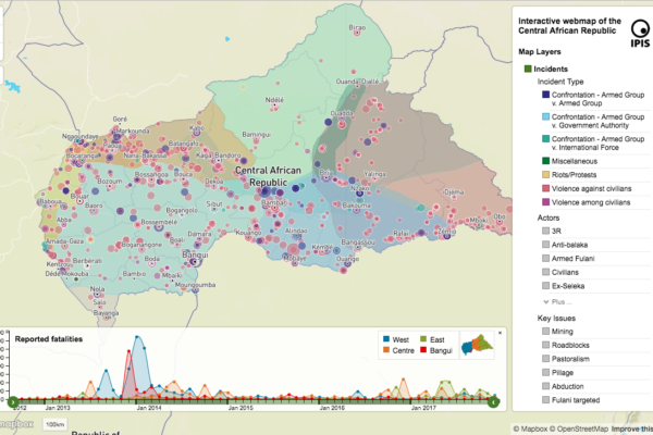
Central African Republic: A Conflict Mapping (2018)
September 16, 2018In a new report and webmap on the longstanding crisis in the Central African Republic (CAR), IPIS points out that access to resources remains the predominant driver of both armament and conflict in CAR. All armed groups operating in CAR are engaged in predation on one or more economic sectors. Such predation is not only a key determinant of an armed group’s movements and activities, but prov
Annual Report 2017
August 21, 2018In its 2017 annual report, IPIS gives an overview of its research projects and activities. It covers the four research programmes that IPIS focusses on: natural resources, arms trade, conflict mapping and business and human rights. IPIS explains among others its mapping work of artisanal mining sites in the Democratic Republic of Congo, its work on Human Rights in mining in Northwest Tanzania an
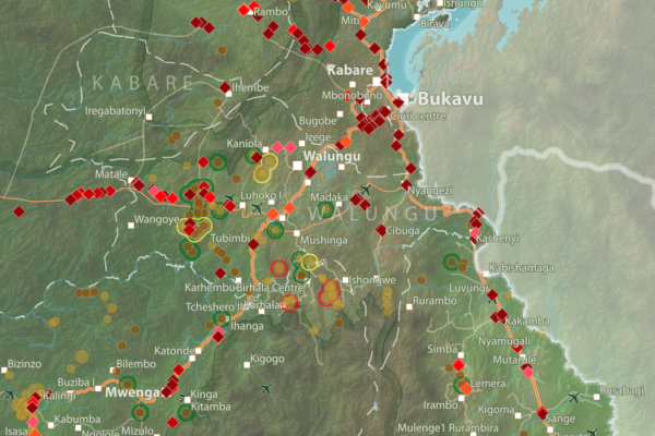
Roadblocks and artisanal mining sites – North and South Kivu Provinces (2018)
March 20, 2018This map show the location of roadblocks and artisanal mining sites in the Kivu provinces. It was made by combining data from our recent report on roadblocks in the area, and data from our recent update of our database and webmap on artisanal mining sites in eastern DRC. Download the full image

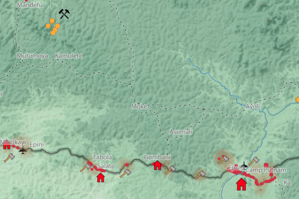
Interactive map of artisanal mining exploitation in eastern DR Congo – 2018 update
March 19, 2018Résumé français ci-dessous – French summary below IPIS launched a major update of it’s DRC webmap displaying data on more than 2400 artisanal mining sites in eastern DRC and more than 800 roadblocks. Since December 2016, IPIS teams have visited more than 500 artisanal mines in eastern DRC, gathering data that has been added to IPIS’ interactive webmap. IPIS also integrated other datasets gathered
Okapi Wildlife Reserve: Illegal Sourcing of Gold and Timber (2018)
February 1, 2018A map of the Okapi Wildlife Reserve in DRC, created as a result of two mapathons focussing on illegal activities in the park.
The Politics of Pillage: the political economy of roadblocks in the Central African Republic (2017)
December 7, 2017IPIS puts roadblocks on the map as key mechanism of conflict funding besides natural resources, revealing its devastating scope in funding armed actors in Democratic Republic of Congo and Central African Republic Mapping over a thousand roadblocks, IPIS uncovers the shocking extent of armed predation on trade routes in conflict-ridden Central Africa. Roadblocks, IPIS claims, have netted armed grou