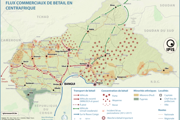
Pastoralism corridors in Central African Republic (2017)
December 1, 2017While pastoralism can generates wealth and economic interdependence between farmers and cattle herders, it can also causes tension and conflicts. In the current Central African Republic crisis context, transnational livestock migrations, particularly by Chadian and Sudanese herdsmen to CAR, have led to clashes between pastoralists and the local population. IPIS has developed a map showing the main
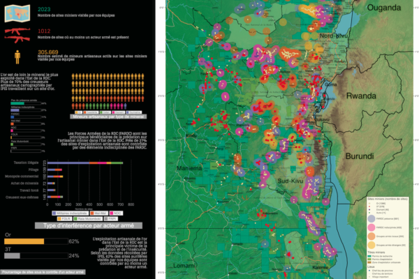
Conflict Minerals in Eastern DRC (2017)
September 22, 2017Printing maps of conflict minerals in Eastern DRC.
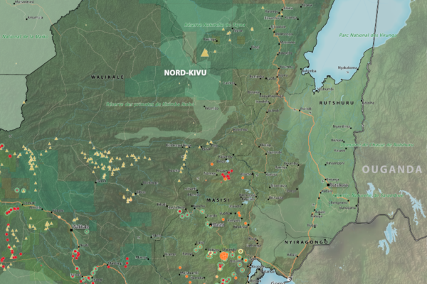
Maps of Mining Sites in North Kivu (2017)
September 21, 2017North Kivu Province – AO Map Lubero, Oicha, Butembo and Beni Territories – A0 Map Masisi Territory – A0 Map Masisi Territory, North Kivu Province, DRC Masisi Territory, North Kivu Province, DRC (Detail) Rutshuru Territory – A0 Map Rutshuru Territory, North Kivu Province, DRC Rutshuru Territory, North Kivu Province, DRC (Detail) Walikale Territory – A0 Map Walikal

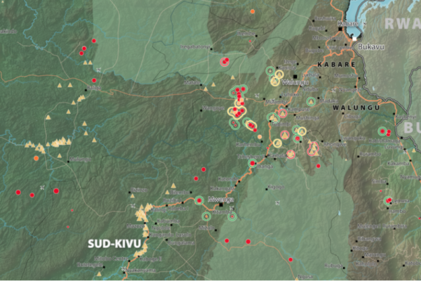
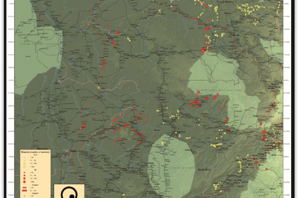
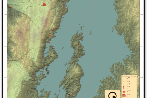
Maps of mining sites in South Kivu (2017)
September 20, 2017South Kivu Province – A0 Map Walungu Territory – A0 Map Idjwi Territory – A0 Map Kabare Territory, South Kivu – A0 Map Kalehe Territory – A0 Map Mwenga Territory – A0 Map Shabunda Territory – A0 Map Uvira Territory – A0 Map
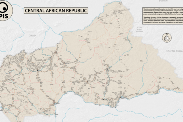
République Centrafricaine: Portait d’un territoire riche en crises (2012 – 2017)
September 19, 2017This poster is a compilation of maps and graphics related to the situation in the Central African Republic. A map of natural resources and poaching corridors presents the known wealth of this country, often considered as conflict drivers in the absence of well functioning state authorities. A small map presents the current armed groups area of influence as well as the number of reported violent in
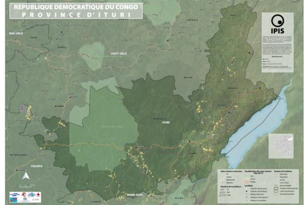
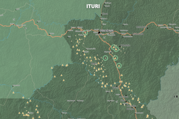
Maps of Mining Sites in Ituri (2017)
September 19, 2017Map of Ituri Province of Ituri, DRC (Detail) Map of Mambasa Territory Territory of Mambasa, Province of Ituri, DRC (Detail)
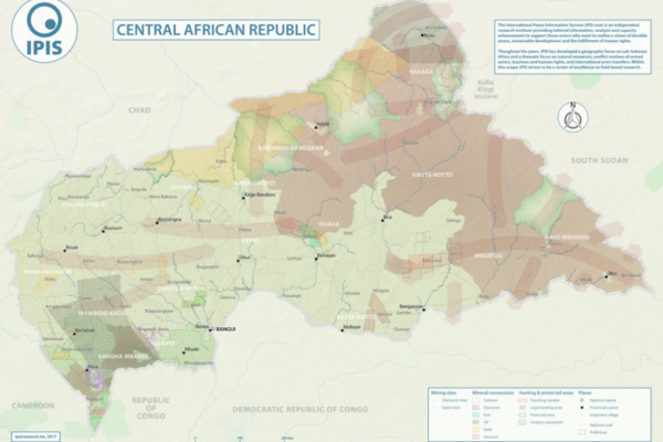
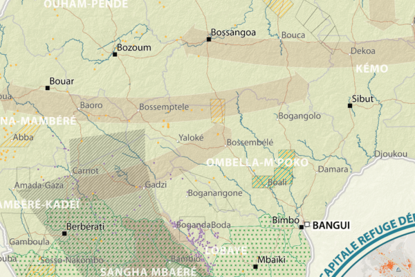
Natural Resources in Central African Republic (2017)
September 12, 2017With an area of 622 984km2, the Central African Republic is the 20th largest country in Africa and one of the poorest in the world. Its economy is highly dependent of the primary sector. Whereas distribution of income is deeply unequal, the unstable political situation and the violent confrontations between different armed groups all around the country weaken the economic growth, especially from
Central African Republic – Road Map (2017)
June 1, 2017In 2013 the Central African Republic entered a period of great instability. The predominantly Muslim rebel coalition, Seleka, seized power. A group of mostly Christian militias, the Anti-balaka, rose up to counter the Seleka. Years of atrocities, horrors and fighting followed. In 2016 a democratic election was held, a sign of hope for the people of the CAR. However, dissolved fractions of the Sele
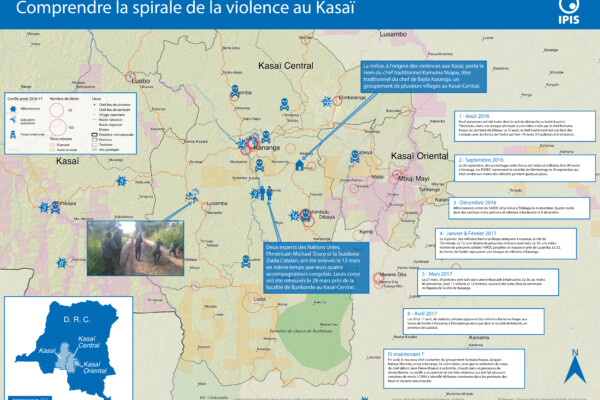
Comprendre la spirale de la violence au Kasaï (2017)
April 25, 2017Le Kasaï Central et trois autres provinces voisines sont en proie à des violences mêlant miliciens, policiers et soldats et ayant fait, selon un rapport récent des Nations Unies, plus de 200 morts. Depuis septembre, un soulèvement des partisans du chef coutumier Kamwina Nsapu, tué en août par les forces de l’ordre après s’être rebellé contre les autorités congolaises, a embrasé la région. L’ONU a
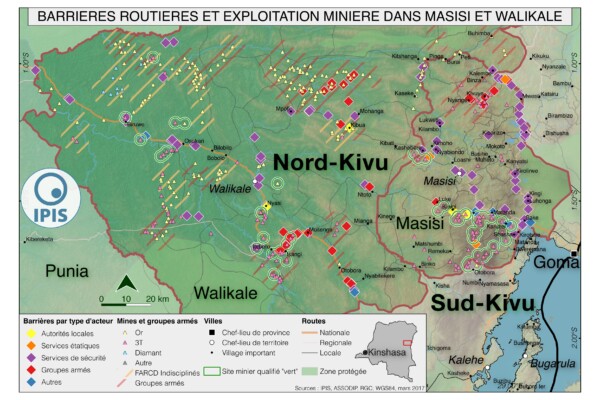
Pillage route: l’économie politique des barrages routiers à Walikale et Masisi (2017)
March 31, 2017French version below – version française ci-dessous Roadblocks are a ubiquitous phenomenon in Eastern Congo. In an effort to map the scope of this phenomenon as well as its significance in the political economy of conflict, IPIS has embarked on a collaboration with the Danish Institute for International Studies. The point of departure is that control over the circulation of people and valua

North Kivu Province – A0 Map
March 5, 2017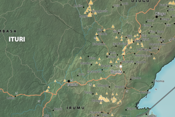
Map of Ituri
February 11, 2017Province of Ituri, DRC (Detail)
South Kivu Province – A0 Map
February 11, 2017South Kivu Province, DRC (Detail)
Map of Mambasa Territory
January 11, 2017Territory of Mambasa, Province of Ituri, DRC (Detail)
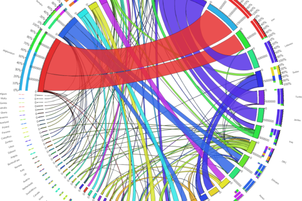
Accessible and Interactive: New Methods of Data Visualization as Tools for Data Analysis and Information Sharing in Transitional Justice Research
March 24, 2016Abstract The production and use of datasets is a growing area in transitional justice research. One constant limitation, however, is the way this data is visualized. Relying only on static graphics and tables, many of these datasets are insufficiently explored and analyzed, and remain inaccessible for other researchers. Interactive data visualization tools are an ideal method for overcoming this g
Maniema province – A0 map (2015)
June 4, 2015This is an A0 map of the Lubutu, Punia and Pangi Territories in Maniema Province, DRC
Idjwi Territory – A0 Map
March 5, 2015Idjwi Territory, South Kivu Province, DRC Idjwi Territory, South Kivu Province, DRC (Detail)
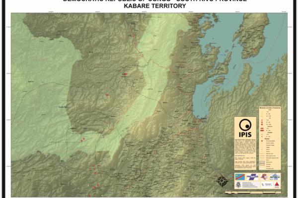
Kabare Territory, South Kivu – A0 Map
March 5, 2015Kabare Territory, South Kivu Province, DRC Kabare Territory, South Kivu Province, DRC (Detail)
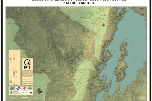
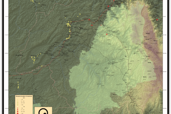
Kalehe Territory – A0 Map
March 5, 2015Kalehe Territory, South Kivu Province, DRC Kalehe Territory, South Kivu Province, DRC (Detail)
Mwenga Territory – A0 Map
March 5, 2015Mwenga Territory, South Kivu Province, DRC Mwenga Territory, South Kivu Province, DRC (Detail)